Phùng geodata
Phùng (Hanoi) is a seat of a second-order administrative division; located in Vietnam in Asia/Ho_Chi_Minh (GMT+7) time zone. In our database, there are 94 cities with bigger population. Compared to other cities in Vietnam, 77.8% of cities are located further ↓South; 70.3% of cities are located further →East and 53.3% of cities have lower elevation than Phùng. Note1


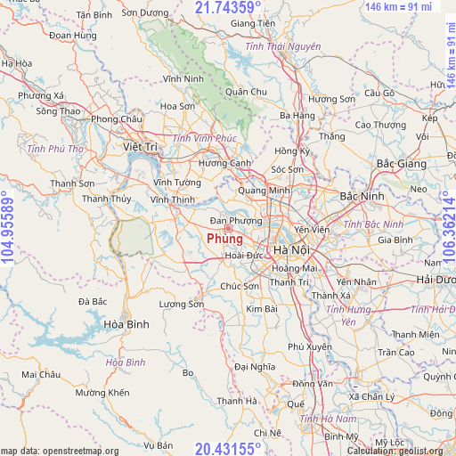
Phùng GPS coordinates[2]
21° 5' 20.472" North, 105° 39' 32.436" East
| Map corner | latitude | longitude |
|---|---|---|
| Upper-left | 21.74359°, | 104.95589° |
| Center: | 21.08902°, | 105.65901° |
| Lower-right: | 20.43155°, | 106.36214° |
| Map W x H: | 145.9×145.9 km | = 90.7×90.7mi |
| max Lat: | 23.27841° ⇑22.2% North |
| Phùng: | 21.08902° |
| min Lat: | ⇓77.8% South 8.65724° |
| min Long | Phùng | max Long |
| 102.4579° | 105.65901° | 112.72541° |
| W 29.7%⇐ | ⇒70.3% E |
Elevation
Elevation of Phùng is 16 m = 52 ft, and this is 113.5 m = 372 ft below average elevation for this country.
| Max E: |
1592 m = 5223 ft | 46.7% |
| Avg. | 129.5 m = 425 ft | |
| Phùng | 16 m = 52 ft | |
Min E: |
-1 m = -3 ft | 53.3% |
See also: Vietnam elevation on elevation.city.
Geographical zone
Phùng is located in North Torrid zone (between Equator and Tropic of Cancer). Distance of this Northern Tropic circle is 261 km =162.2 mi to North.| Distance of | km | miles | from Phùng |
|---|---|---|---|
| North Pole | 7662.2 | 4761.1 | to North |
| Arctic Circle | 5056.3 | 3141.8 | to North |
| Tropic Cancer | 261 | 162.2 | to North |
| Equator | 2344.9 | 1457.1 | to South |


Nearby cities:
15 places around Phùng: (largest is in red/bold)
• Chúc Sơn
18.9 km =11.7 mi,  166°
166°
• Cầu Diễn
12.5 km =7.8 mi,  116°
116°
• Cầu Giấy
16 km =9.9 mi,  113°
113°
• Hà Đông
18 km =11.2 mi,  136°
136°
• Liên Quan
9 km =5.6 mi,  246°
246°
• Mê Linh
12.2 km =7.6 mi,  31°
31°
• Phúc Thọ
11.9 km =7.4 mi,  277°
277°
• Phúc Yên
17.1 km =10.6 mi,  16°
16°
• Quốc Oai
11.1 km =6.9 mi,  189°
189°
• Sơn Tây
16.8 km =10.4 mi,  289°
289°
• Thanh Xuân
18 km =11.2 mi,  125°
125°
• Trôi
5.4 km =3.4 mi, 113°
• Tây Hồ
15.9 km =9.9 mi,  98°
98°
• Yên Lạc
18.7 km =11.6 mi,  331°
331°
• Đống Đa
19.4 km =12.1 mi, 113°
Sources, notices
• [Note1] Compared only with cities in Vietnam existing in our database
• [Src1] Map data: © OpenStreetMap contributors (CC-BY-SA)
• [Src2] Other city data from geonames.org with taken over terms of usage.
• [Src3] Geographical zone / Annual Mean Temperature by Robert A. Rohde @ Wikipedia
