Tư Nghĩa geodata
Tư Nghĩa (Quảng Ngãi Province) is a seat of a second-order administrative division; located in Vietnam in Asia/Ho_Chi_Minh (GMT+7) time zone. In our database, there are 94 cities with bigger population. Compared to other cities in Vietnam, 56.6% of cities are located further ↑North; 94.6% of cities are located further ←West and 58.1% of cities have higher elevation than Tư Nghĩa. Note1


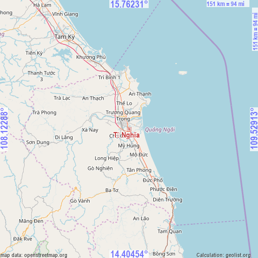
Tư Nghĩa GPS coordinates[2]
15° 5' 4.236" North, 108° 49' 33.6" East
| Map corner | latitude | longitude |
|---|---|---|
| Upper-left | 15.76231°, | 108.12288° |
| Center: | 15.08451°, | 108.826° |
| Lower-right: | 14.40454°, | 109.52913° |
| Map W x H: | 151×151 km | = 93.8×93.8mi |
| max Lat: | 23.27841° ⇑56.6% North |
| Tư Nghĩa: | 15.08451° |
| min Lat: | ⇓43.4% South 8.65724° |
| min Long | Tư Nghĩa | max Long |
| 102.4579° | 108.826° | 112.72541° |
| W 94.6%⇐ | ⇒5.4% E |
Elevation
Elevation of Tư Nghĩa is 11 m = 36 ft, and this is 118.5 m = 389 ft below average elevation for this country.
| Max E: |
1592 m = 5223 ft | 58.1% |
| Avg. | 129.5 m = 425 ft | |
| Tư Nghĩa | 11 m = 36 ft | |
Min E: |
-1 m = -3 ft | 41.9% |
See also: Vietnam elevation on elevation.city.
Geographical zone
Tư Nghĩa is located in North Torrid zone (between Equator and Tropic of Cancer). Distance of this Northern Tropic circle is 928.7 km =577.1 mi to North.| Distance of | km | miles | from Tư Nghĩa |
|---|---|---|---|
| North Pole | 8329.8 | 5175.9 | to North |
| Arctic Circle | 5723.9 | 3556.7 | to North |
| Tropic Cancer | 928.7 | 577.1 | to North |
| Equator | 1677.2 | 1042.2 | to South |


Nearby cities:
15 places around Tư Nghĩa: (largest is in red/bold)
• An Lão
52.9 km =32.9 mi,  172°
172°
• Ba Tơ
37.1 km =23.1 mi,  195°
195°
• Bình Sơn
24.7 km =15.3 mi,  343°
343°
• Lý Sơn
44.8 km =27.8 mi,  44°
44°
• Minh Long
21.5 km =13.4 mi,  217°
217°
• Mộ Đức
15.8 km =9.8 mi,  155°
155°
• Nghĩa Hành
6.8 km =4.2 mi,  230°
230°
• Núi Thành
42.6 km =26.5 mi, 335°
• Pho Duc
33.4 km =20.8 mi,  154°
154°
• Quảng Ngãi
5.4 km =3.4 mi,  317°
317°
• Sơn Hà
38.5 km =23.9 mi,  262°
262°
• Sơn Tịnh
8.8 km =5.5 mi, 338°
• Tam Kỳ
66.2 km =41.1 mi,  325°
325°
• Trà Bồng
38.2 km =23.7 mi,  299°
299°
• Tây Trà
50.9 km =31.6 mi,  280°
280°
Sources, notices
• [Note1] Compared only with cities in Vietnam existing in our database
• [Src1] Map data: © OpenStreetMap contributors (CC-BY-SA)
• [Src2] Other city data from geonames.org with taken over terms of usage.
• [Src3] Geographical zone / Annual Mean Temperature by Robert A. Rohde @ Wikipedia
