Núi Thành geodata
Núi Thành (Quảng Nam) is a seat of a second-order administrative division; located in Vietnam in Asia/Ho_Chi_Minh (GMT+7) time zone. In our database, there are 94 cities with bigger population. Compared to other cities in Vietnam, 55.1% of cities are located further ↑North; 92.7% of cities are located further ←West and 71.9% of cities have higher elevation than Núi Thành. Note1


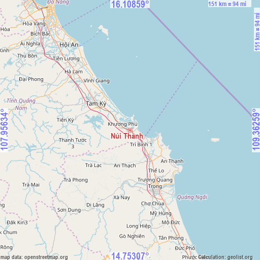
Núi Thành GPS coordinates[2]
15° 25' 54.984" North, 108° 39' 34.056" East
| Map corner | latitude | longitude |
|---|---|---|
| Upper-left | 16.10859°, | 107.95634° |
| Center: | 15.43194°, | 108.65946° |
| Lower-right: | 14.75307°, | 109.36259° |
| Map W x H: | 150.7×150.7 km | = 93.6×93.6mi |
| max Lat: | 23.27841° ⇑55.1% North |
| Núi Thành: | 15.43194° |
| min Lat: | ⇓44.9% South 8.65724° |
| min Long | Núi Thành | max Long |
| 102.4579° | 108.65946° | 112.72541° |
| W 92.7%⇐ | ⇒7.3% E |
Elevation
Elevation of Núi Thành is 8 m = 26 ft, and this is 121.5 m = 399 ft below average elevation for this country.
| Max E: |
1592 m = 5223 ft | 71.9% |
| Avg. | 129.5 m = 425 ft | |
| Núi Thành | 8 m = 26 ft | |
Min E: |
-1 m = -3 ft | 28.1% |
See also: Vietnam elevation on elevation.city.
Geographical zone
Núi Thành is located in North Torrid zone (between Equator and Tropic of Cancer). Distance of this Northern Tropic circle is 890 km =553 mi to North.| Distance of | km | miles | from Núi Thành |
|---|---|---|---|
| North Pole | 8291.2 | 5151.9 | to North |
| Arctic Circle | 5685.3 | 3532.7 | to North |
| Tropic Cancer | 890 | 553 | to North |
| Equator | 1715.9 | 1066.2 | to South |


Nearby cities:
15 places around Núi Thành: (largest is in red/bold)
• Bình Sơn
18.5 km =11.5 mi,  143°
143°
• Hà Lam
47.5 km =29.5 mi,  315°
315°
• Lý Sơn
49.7 km =30.9 mi,  97°
97°
• Nghĩa Hành
44.8 km =27.8 mi,  163°
163°
• Phú Ninh
29.9 km =18.6 mi,  297°
297°
• Quảng Ngãi
37.4 km =23.2 mi, 157°
• Quế Sơn
54.2 km =33.7 mi, 299°
• Sơn Hà
47.9 km =29.8 mi,  205°
205°
• Sơn Tịnh
33.7 km =20.9 mi,  154°
154°
• Tam Kỳ
25.4 km =15.8 mi,  308°
308°
• Tiên Phước
38.2 km =23.7 mi,  279°
279°
• Trà Bồng
24.8 km =15.4 mi,  217°
217°
• Trà My
48.1 km =29.9 mi,  257°
257°
• Tây Trà
43.4 km =27 mi,  227°
227°
• Tư Nghĩa
42.6 km =26.5 mi, 155°
Sources, notices
• [Note1] Compared only with cities in Vietnam existing in our database
• [Src1] Map data: © OpenStreetMap contributors (CC-BY-SA)
• [Src2] Other city data from geonames.org with taken over terms of usage.
• [Src3] Geographical zone / Annual Mean Temperature by Robert A. Rohde @ Wikipedia
