Rạch Giá geodata
Rạch Giá (Kiến Giang) is a seat of a first-order administrative division; located in Vietnam in Asia/Ho_Chi_Minh (GMT+7) time zone. With population of 228,356 people, there are 8 cities with bigger population in this country. Compared to other cities in Vietnam, 92.2% of cities are located further ↑North; 88.1% of cities are located further →East and 52.4% of cities have higher elevation than Rạch Giá. Note1


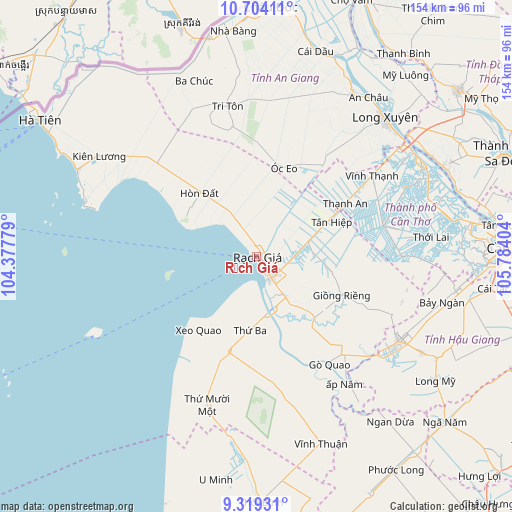
Rạch Giá GPS coordinates[2]
10° 0' 44.82" North, 105° 4' 51.276" East
| Map corner | latitude | longitude |
|---|---|---|
| Upper-left | 10.70411°, | 104.37779° |
| Center: | 10.01245°, | 105.08091° |
| Lower-right: | 9.31931°, | 105.78404° |
| Map W x H: | 154×154 km | = 95.7×95.7mi |
| max Lat: | 23.27841° ⇑92.2% North |
| Rạch Giá: | 10.01245° |
| min Lat: | ⇓7.8% South 8.65724° |
| min Long | Rạch Giá | max Long |
| 102.4579° | 105.08091° | 112.72541° |
| W 11.9%⇐ | ⇒88.1% E |
Elevation
Elevation of Rạch Giá is 13 m = 43 ft, and this is 116.5 m = 382 ft below average elevation for this country.
| Max E: |
1592 m = 5223 ft | 52.4% |
| Avg. | 129.5 m = 425 ft | |
| Rạch Giá | 13 m = 43 ft | |
Min E: |
-1 m = -3 ft | 47.6% |
See also: Rạch Giá elevation on elevation.city.
Geographical zone
Rạch Giá is located in North Torrid zone (between Equator and Tropic of Cancer). Distance of Equator is 1113.3 km =691.8 mi to South.| Distance of | km | miles | from Rạch Giá |
|---|---|---|---|
| North Pole | 8893.8 | 5526.3 | to North |
| Arctic Circle | 6287.9 | 3907.1 | to North |
| Tropic Cancer | 1492.6 | 927.5 | to North |
| Equator | 1113.3 | 691.8 | to South |


Nearby cities:
15 places around Rạch Giá: (largest is in red/bold)
• An Biên
22 km =13.7 mi,  184°
184°
• Cờ Đỏ
39.2 km =24.4 mi,  76°
76°
• Giồng Riềng
28 km =17.4 mi,  114°
114°
• Gò Quao
37.6 km =23.4 mi,  145°
145°
• Kiên Lương
56.5 km =35.1 mi,  302°
302°
• Long Xuyên
56.8 km =35.3 mi,  42°
42°
• Minh Lương
15 km =9.3 mi,  144°
144°
• Ngoc Hon Doc
25.3 km =15.7 mi,  319°
319°
• Núi Sập
34.7 km =21.6 mi, 35°
• Thới Lai
52.6 km =32.7 mi, 83°
• Thứ Mười Một
47 km =29.2 mi,  198°
198°
• Tri Tôn
46.2 km =28.7 mi,  349°
349°
• Tân Hiệp
25.3 km =15.7 mi,  62°
62°
• Vĩnh Thạnh
41.9 km =26 mi, 56°
• Vị Thanh
49.6 km =30.8 mi,  120°
120°
Sources, notices
• [Note1] Compared only with cities in Vietnam existing in our database
• [Src1] Map data: © OpenStreetMap contributors (CC-BY-SA)
• [Src2] Other city data from geonames.org with taken over terms of usage.
• [Src3] Geographical zone / Annual Mean Temperature by Robert A. Rohde @ Wikipedia
