Thứ Mười Một geodata
Thứ Mười Một (Kiến Giang) is a seat of a second-order administrative division; located in Vietnam in Asia/Ho_Chi_Minh (GMT+7) time zone. In our database, there are 94 cities with bigger population. Compared to other cities in Vietnam, 96.4% of cities are located further ↑North; 90.9% of cities are located further →East and 99.2% of cities have higher elevation than Thứ Mười Một. Note1


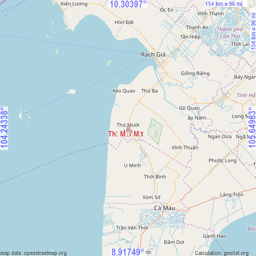
Thứ Mười Một GPS coordinates[2]
9° 36' 41.184" North, 104° 56' 47.4" East
| Map corner | latitude | longitude |
|---|---|---|
| Upper-left | 10.30397°, | 104.24338° |
| Center: | 9.61144°, | 104.9465° |
| Lower-right: | 8.91749°, | 105.64963° |
| Map W x H: | 154.2×154.2 km | = 95.8×95.8mi |
| max Lat: | 23.27841° ⇑96.4% North |
| Thứ Mười Một: | 9.61144° |
| min Lat: | ⇓3.6% South 8.65724° |
| min Long | Thứ Mười M | max Long |
| 102.4579° | 104.9465° | 112.72541° |
| W 9.1%⇐ | ⇒90.9% E |
Elevation
Elevation of Thứ Mười Một is 1 m = 3 ft, and this is 128.5 m = 422 ft below average elevation for this country.
| Max E: |
1592 m = 5223 ft | 99.2% |
| Avg. | 129.5 m = 425 ft | |
| Thứ Mười Một | 1 m = 3 ft | |
Min E: |
-1 m = -3 ft | 0.8% |
See also: Vietnam elevation on elevation.city.
Geographical zone
Thứ Mười Một is located in North Torrid zone (between Equator and Tropic of Cancer). Distance of Equator is 1068.7 km =664.1 mi to South.| Distance of | km | miles | from Thứ Mười Một |
|---|---|---|---|
| North Pole | 8938.4 | 5554.1 | to North |
| Arctic Circle | 6332.5 | 3934.8 | to North |
| Tropic Cancer | 1537.2 | 955.2 | to North |
| Equator | 1068.7 | 664.1 | to South |


Nearby cities:
15 places around Thứ Mười Một: (largest is in red/bold)
• An Biên
26.1 km =16.2 mi,  29°
29°
• Cà Mau
53.3 km =33.1 mi,  154°
154°
• Giồng Riềng
52.2 km =32.4 mi,  50°
50°
• Gò Quao
38.4 km =23.9 mi,  69°
69°
• Minh Lương
39.9 km =24.8 mi,  35°
35°
• Ngoc Hon Doc
63.8 km =39.6 mi,  358°
358°
• Nàng Mau
66.3 km =41.2 mi,  76°
76°
• Rạch Giá
47 km =29.2 mi,  18°
18°
• Thị Trấn Ngan Dừa
55.4 km =34.4 mi,  95°
95°
• Thị Trấn Phước Long
59.8 km =37.2 mi,  108°
108°
• Thới Bình
33 km =20.5 mi, 149°
• Trần Văn Thời
59.5 km =37 mi,  176°
176°
• U Minh
22.3 km =13.9 mi,  172°
172°
• Vĩnh Thuận
36 km =22.4 mi, 108°
• Vị Thanh
60.5 km =37.6 mi, 71°
Sources, notices
• [Note1] Compared only with cities in Vietnam existing in our database
• [Src1] Map data: © OpenStreetMap contributors (CC-BY-SA)
• [Src2] Other city data from geonames.org with taken over terms of usage.
• [Src3] Geographical zone / Annual Mean Temperature by Robert A. Rohde @ Wikipedia
