Cờ Đỏ geodata
Cờ Đỏ (Can Tho) is a seat of a second-order administrative division; located in Vietnam in Asia/Ho_Chi_Minh (GMT+7) time zone. In our database, there are 94 cities with bigger population. Compared to other cities in Vietnam, 91% of cities are located further ↑North; 79% of cities are located further →East and 92.5% of cities have higher elevation than Cờ Đỏ. Note1


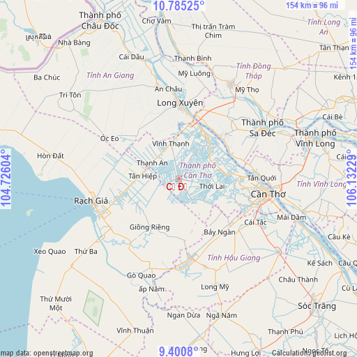
Cờ Đỏ GPS coordinates[2]
10° 5' 37.572" North, 105° 25' 44.976" East
| Map corner | latitude | longitude |
|---|---|---|
| Upper-left | 10.78525°, | 104.72604° |
| Center: | 10.09377°, | 105.42916° |
| Lower-right: | 9.4008°, | 106.13229° |
| Map W x H: | 153.9×153.9 km | = 95.6×95.6mi |
| max Lat: | 23.27841° ⇑91% North |
| Cờ Đỏ: | 10.09377° |
| min Lat: | ⇓9% South 8.65724° |
| min Long | Cờ Đỏ | max Long |
| 102.4579° | 105.42916° | 112.72541° |
| W 21%⇐ | ⇒79% E |
Elevation
Elevation of Cờ Đỏ is 4 m = 13 ft, and this is 125.5 m = 412 ft below average elevation for this country.
| Max E: |
1592 m = 5223 ft | 92.5% |
| Avg. | 129.5 m = 425 ft | |
| Cờ Đỏ | 4 m = 13 ft | |
Min E: |
-1 m = -3 ft | 7.5% |
See also: Vietnam elevation on elevation.city.
Geographical zone
Cờ Đỏ is located in North Torrid zone (between Equator and Tropic of Cancer). Distance of Equator is 1122.3 km =697.4 mi to South.| Distance of | km | miles | from Cờ Đỏ |
|---|---|---|---|
| North Pole | 8884.7 | 5520.7 | to North |
| Arctic Circle | 6278.9 | 3901.5 | to North |
| Tropic Cancer | 1483.6 | 921.9 | to North |
| Equator | 1122.3 | 697.4 | to South |


Nearby cities:
15 places around Cờ Đỏ: (largest is in red/bold)
• Bình Thủy
34.1 km =21.2 mi,  93°
93°
• Giồng Riềng
24 km =14.9 mi,  211°
211°
• Lai Vung
33.3 km =20.7 mi,  49°
49°
• Long Xuyên
32.5 km =20.2 mi,  1°
1°
• Lấp Vò
31.4 km =19.5 mi,  18°
18°
• Một Ngàn
29 km =18 mi,  130°
130°
• Núi Sập
26 km =16.2 mi,  316°
316°
• Phong Điền
28.2 km =17.5 mi,  112°
112°
• Thị Trấn Tân Thành
25.4 km =15.8 mi,  44°
44°
• Thốt Nốt
22.9 km =14.2 mi,  30°
30°
• Thới Lai
14.5 km =9 mi,  102°
102°
• Tân Hiệp
15.9 km =9.9 mi,  279°
279°
• Vĩnh Thạnh
14.7 km =9.1 mi,  346°
346°
• Vị Thanh
34.7 km =21.6 mi,  172°
172°
• Ô Môn
21.3 km =13.2 mi, 85°
Sources, notices
• [Note1] Compared only with cities in Vietnam existing in our database
• [Src1] Map data: © OpenStreetMap contributors (CC-BY-SA)
• [Src2] Other city data from geonames.org with taken over terms of usage.
• [Src3] Geographical zone / Annual Mean Temperature by Robert A. Rohde @ Wikipedia
