Vĩnh Thạnh geodata
Vĩnh Thạnh (Can Tho) is a seat of a second-order administrative division; located in Vietnam in Asia/Ho_Chi_Minh (GMT+7) time zone. In our database, there are 94 cities with bigger population. Compared to other cities in Vietnam, 89.2% of cities are located further ↑North; 80.4% of cities are located further →East and 95.4% of cities have higher elevation than Vĩnh Thạnh. Note1


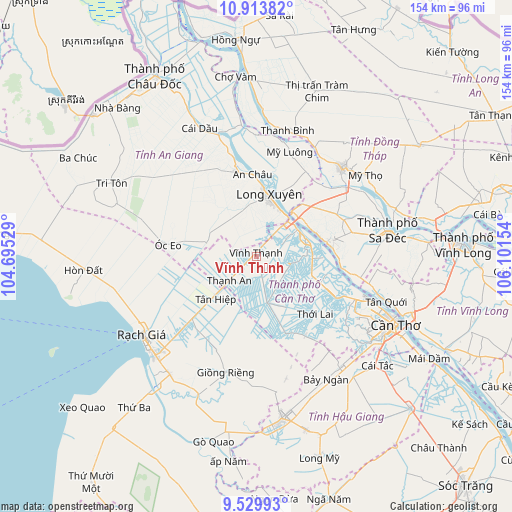
Vĩnh Thạnh GPS coordinates[2]
10° 13' 21.468" North, 105° 23' 54.276" East
| Map corner | latitude | longitude |
|---|---|---|
| Upper-left | 10.91382°, | 104.69529° |
| Center: | 10.22263°, | 105.39841° |
| Lower-right: | 9.52993°, | 106.10154° |
| Map W x H: | 153.9×153.9 km | = 95.6×95.6mi |
| max Lat: | 23.27841° ⇑89.2% North |
| Vĩnh Thạnh: | 10.22263° |
| min Lat: | ⇓10.8% South 8.65724° |
| min Long | Vĩnh Thạnh | max Long |
| 102.4579° | 105.39841° | 112.72541° |
| W 19.6%⇐ | ⇒80.4% E |
Elevation
Elevation of Vĩnh Thạnh is 3 m = 10 ft, and this is 126.5 m = 415 ft below average elevation for this country.
| Max E: |
1592 m = 5223 ft | 95.4% |
| Avg. | 129.5 m = 425 ft | |
| Vĩnh Thạnh | 3 m = 10 ft | |
Min E: |
-1 m = -3 ft | 4.6% |
See also: Vietnam elevation on elevation.city.
Geographical zone
Vĩnh Thạnh is located in North Torrid zone (between Equator and Tropic of Cancer). Distance of Equator is 1136.6 km =706.3 mi to South.| Distance of | km | miles | from Vĩnh Thạnh |
|---|---|---|---|
| North Pole | 8870.4 | 5511.8 | to North |
| Arctic Circle | 6264.5 | 3892.6 | to North |
| Tropic Cancer | 1469.3 | 913 | to North |
| Equator | 1136.6 | 706.3 | to South |


Nearby cities:
15 places around Vĩnh Thạnh: (largest is in red/bold)
• An Châu
24.8 km =15.4 mi,  356°
356°
• Cao Lãnh
36.8 km =22.9 mi,  44°
44°
• Chợ Mới
36.5 km =22.7 mi,  1°
1°
• Cờ Đỏ
14.7 km =9.1 mi,  166°
166°
• Giồng Riềng
36 km =22.4 mi,  194°
194°
• Lai Vung
29.7 km =18.5 mi,  76°
76°
• Long Xuyên
18.6 km =11.6 mi,  12°
12°
• Lấp Vò
20.3 km =12.6 mi, 40°
• Núi Sập
15.1 km =9.4 mi,  288°
288°
• Phong Điền
38.6 km =24 mi,  130°
130°
• Thị Trấn Tân Thành
21.6 km =13.4 mi, 80°
• Thốt Nốt
15.8 km =9.8 mi,  69°
69°
• Thới Lai
24.8 km =15.4 mi, 134°
• Tân Hiệp
17 km =10.6 mi,  226°
226°
• Ô Môn
27.6 km =17.1 mi,  117°
117°
Sources, notices
• [Note1] Compared only with cities in Vietnam existing in our database
• [Src1] Map data: © OpenStreetMap contributors (CC-BY-SA)
• [Src2] Other city data from geonames.org with taken over terms of usage.
• [Src3] Geographical zone / Annual Mean Temperature by Robert A. Rohde @ Wikipedia
