Giồng Riềng geodata
Giồng Riềng (Kiến Giang) is a seat of a second-order administrative division; located in Vietnam in Asia/Ho_Chi_Minh (GMT+7) time zone. In our database, there are 94 cities with bigger population. Compared to other cities in Vietnam, 93.5% of cities are located further ↑North; 82.4% of cities are located further →East and 95.4% of cities have higher elevation than Giồng Riềng. Note1


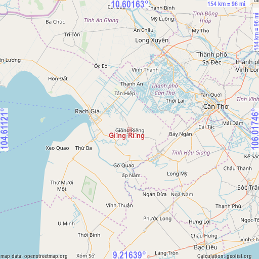
Giồng Riềng GPS coordinates[2]
9° 54' 35.064" North, 105° 18' 51.588" East
| Map corner | latitude | longitude |
|---|---|---|
| Upper-left | 10.60163°, | 104.61121° |
| Center: | 9.90974°, | 105.31433° |
| Lower-right: | 9.21639°, | 106.01746° |
| Map W x H: | 154×154 km | = 95.7×95.7mi |
| max Lat: | 23.27841° ⇑93.5% North |
| Giồng Riềng: | 9.90974° |
| min Lat: | ⇓6.5% South 8.65724° |
| min Long | Giồng Riềng | max Long |
| 102.4579° | 105.31433° | 112.72541° |
| W 17.6%⇐ | ⇒82.4% E |
Elevation
Elevation of Giồng Riềng is 3 m = 10 ft, and this is 126.5 m = 415 ft below average elevation for this country.
| Max E: |
1592 m = 5223 ft | 95.4% |
| Avg. | 129.5 m = 425 ft | |
| Giồng Riềng | 3 m = 10 ft | |
Min E: |
-1 m = -3 ft | 4.6% |
See also: Vietnam elevation on elevation.city.
Geographical zone
Giồng Riềng is located in North Torrid zone (between Equator and Tropic of Cancer). Distance of Equator is 1101.9 km =684.7 mi to South.| Distance of | km | miles | from Giồng Riềng |
|---|---|---|---|
| North Pole | 8905.2 | 5533.4 | to North |
| Arctic Circle | 6299.3 | 3914.2 | to North |
| Tropic Cancer | 1504.1 | 934.6 | to North |
| Equator | 1101.9 | 684.7 | to South |


Nearby cities:
15 places around Giồng Riềng: (largest is in red/bold)
• An Biên
29.4 km =18.3 mi,  249°
249°
• Cờ Đỏ
24 km =14.9 mi,  31°
31°
• Gò Quao
20.1 km =12.5 mi,  192°
192°
• Long Mỹ
38 km =23.6 mi,  131°
131°
• Minh Lương
17 km =10.6 mi,  267°
267°
• Một Ngàn
34.6 km =21.5 mi,  87°
87°
• Nàng Mau
29.9 km =18.6 mi, 126°
• Núi Sập
39.8 km =24.7 mi,  352°
352°
• Phong Điền
39.9 km =24.8 mi,  75°
75°
• Rạch Giá
28 km =17.4 mi,  294°
294°
• Thới Lai
31.9 km =19.8 mi,  57°
57°
• Tân Hiệp
23.3 km =14.5 mi, 352°
• Vĩnh Thạnh
36 km =22.4 mi,  14°
14°
• Vị Thanh
22 km =13.7 mi, 129°
• Ô Môn
40.5 km =25.2 mi, 56°
Sources, notices
• [Note1] Compared only with cities in Vietnam existing in our database
• [Src1] Map data: © OpenStreetMap contributors (CC-BY-SA)
• [Src2] Other city data from geonames.org with taken over terms of usage.
• [Src3] Geographical zone / Annual Mean Temperature by Robert A. Rohde @ Wikipedia
