Cành Nàng geodata
Cành Nàng (Thanh Hóa) is a seat of a second-order administrative division; located in Vietnam in Asia/Ho_Chi_Minh (GMT+7) time zone. In our database, there are 94 cities with bigger population. Compared to other cities in Vietnam, 63% of cities are located further ↓South; 85.3% of cities are located further →East and 70.6% of cities have lower elevation than Cành Nàng. Note1


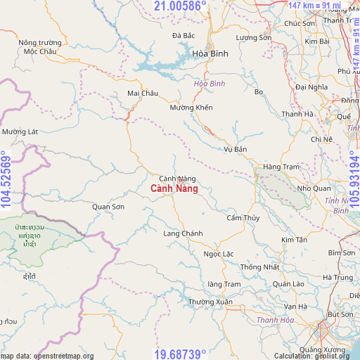
Cành Nàng GPS coordinates[2]
20° 20' 52.908" North, 105° 13' 43.716" East
| Map corner | latitude | longitude |
|---|---|---|
| Upper-left | 21.00586°, | 104.52569° |
| Center: | 20.34803°, | 105.22881° |
| Lower-right: | 19.68739°, | 105.93194° |
| Map W x H: | 146.6×146.6 km | = 91.1×91.1mi |
| max Lat: | 23.27841° ⇑37% North |
| Cành Nàng: | 20.34803° |
| min Lat: | ⇓63% South 8.65724° |
| min Long | Cành Nàng | max Long |
| 102.4579° | 105.22881° | 112.72541° |
| W 14.7%⇐ | ⇒85.3% E |
Elevation
Elevation of Cành Nàng is 59 m = 194 ft, and this is 70.5 m = 231 ft below average elevation for this country.
| Max E: |
1592 m = 5223 ft | 29.4% |
| Avg. | 129.5 m = 425 ft | |
| Cành Nàng | 59 m = 194 ft | |
Min E: |
-1 m = -3 ft | 70.6% |
See also: Vietnam elevation on elevation.city.
Geographical zone
Cành Nàng is located in North Torrid zone (between Equator and Tropic of Cancer). Distance of this Northern Tropic circle is 343.4 km =213.4 mi to North.| Distance of | km | miles | from Cành Nàng |
|---|---|---|---|
| North Pole | 7744.6 | 4812.3 | to North |
| Arctic Circle | 5138.7 | 3193 | to North |
| Tropic Cancer | 343.4 | 213.4 | to North |
| Equator | 2262.5 | 1405.9 | to South |


Nearby cities:
15 places around Cành Nàng: (largest is in red/bold)
• Bo
48.2 km =30 mi,  41°
41°
• Cao Phong
40.8 km =25.4 mi,  13°
13°
• Cẩm Thủy
29.5 km =18.3 mi,  121°
121°
• Hàng Trạm
41.4 km =25.7 mi,  82°
82°
• Hòa Bình
53.4 km =33.2 mi, 12°
• Kim Tân
52.4 km =32.6 mi, 117°
• Lang Chánh
21.4 km =13.3 mi,  176°
176°
• Mường Khến
30.1 km =18.7 mi, 10°
• Ngọc Lặc
32 km =19.9 mi,  153°
153°
• Nho Quan
54.6 km =33.9 mi,  92°
92°
• Quan Hóa
14 km =8.7 mi,  286°
286°
• Quan Sơn
31.2 km =19.4 mi,  251°
251°
• Thường Xuân
51 km =31.7 mi,  165°
165°
• Vĩnh Lộc
51.9 km =32.2 mi,  128°
128°
• Vụ Bản
25.8 km =16 mi,  59°
59°
Sources, notices
• [Note1] Compared only with cities in Vietnam existing in our database
• [Src1] Map data: © OpenStreetMap contributors (CC-BY-SA)
• [Src2] Other city data from geonames.org with taken over terms of usage.
• [Src3] Geographical zone / Annual Mean Temperature by Robert A. Rohde @ Wikipedia
