Hữu Lũng geodata
Hữu Lũng (Lạng Sơn) is a seat of a second-order administrative division; located in Vietnam in Asia/Ho_Chi_Minh (GMT+7) time zone. In our database, there are 94 cities with bigger population. Compared to other cities in Vietnam, 86% of cities are located further ↓South; 58.1% of cities are located further ←West and 63.6% of cities have lower elevation than Hữu Lũng. Note1


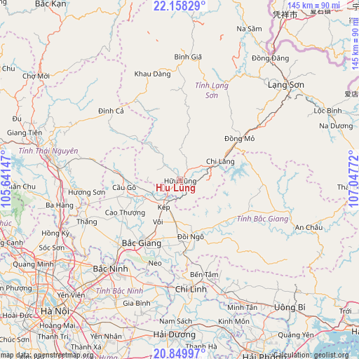
Hữu Lũng GPS coordinates[2]
21° 30' 20.16" North, 106° 20' 40.524" East
| Map corner | latitude | longitude |
|---|---|---|
| Upper-left | 22.15829°, | 105.64147° |
| Center: | 21.5056°, | 106.34459° |
| Lower-right: | 20.84997°, | 107.04772° |
| Map W x H: | 145.5×145.5 km | = 90.4×90.4mi |
| max Lat: | 23.27841° ⇑14% North |
| Hữu Lũng: | 21.5056° |
| min Lat: | ⇓86% South 8.65724° |
| min Long | Hữu Lũng | max Long |
| 102.4579° | 106.34459° | 112.72541° |
| W 58.1%⇐ | ⇒41.9% E |
Elevation
Elevation of Hữu Lũng is 31 m = 102 ft, and this is 98.5 m = 323 ft below average elevation for this country.
| Max E: |
1592 m = 5223 ft | 36.4% |
| Avg. | 129.5 m = 425 ft | |
| Hữu Lũng | 31 m = 102 ft | |
Min E: |
-1 m = -3 ft | 63.6% |
See also: Vietnam elevation on elevation.city.
Geographical zone
Hữu Lũng is located in North Torrid zone (between Equator and Tropic of Cancer). Distance of this Northern Tropic circle is 214.7 km =133.4 mi to North.| Distance of | km | miles | from Hữu Lũng |
|---|---|---|---|
| North Pole | 7615.9 | 4732.3 | to North |
| Arctic Circle | 5010 | 3113.1 | to North |
| Tropic Cancer | 214.7 | 133.4 | to North |
| Equator | 2391.2 | 1485.8 | to South |


Nearby cities:
15 places around Hữu Lũng: (largest is in red/bold)
• Bích Động
36 km =22.4 mi,  224°
224°
• Bắc Giang
30.2 km =18.8 mi,  210°
210°
• Bắc Ninh
45.1 km =28 mi, 218°
• Bắc Sơn
43.9 km =27.3 mi,  356°
356°
• Cao Thượng
25.9 km =16.1 mi,  239°
239°
• Chũ
27.2 km =16.9 mi,  122°
122°
• Cung Kiệm
40.2 km =25 mi, 208°
• Cầu Gồ
22.8 km =14.2 mi,  261°
261°
• Hương Sơn
38.3 km =23.8 mi, 262°
• Neo
35.4 km =22 mi,  196°
196°
• Phố Mới
44 km =27.3 mi, 207°
• Thắng
41 km =25.5 mi,  245°
245°
• Văn Quan
44.8 km =27.8 mi,  26°
26°
• Đồi Ngô
22.6 km =14 mi,  168°
168°
• Đồng Mỏ
29.5 km =18.3 mi,  55°
55°
Sources, notices
• [Note1] Compared only with cities in Vietnam existing in our database
• [Src1] Map data: © OpenStreetMap contributors (CC-BY-SA)
• [Src2] Other city data from geonames.org with taken over terms of usage.
• [Src3] Geographical zone / Annual Mean Temperature by Robert A. Rohde @ Wikipedia
