Đồng Mỏ geodata
Đồng Mỏ (Lạng Sơn) is a seat of a second-order administrative division; located in Vietnam in Asia/Ho_Chi_Minh (GMT+7) time zone. In our database, there are 94 cities with bigger population. Compared to other cities in Vietnam, 87.8% of cities are located further ↓South; 64.6% of cities are located further ←West and 72.1% of cities have lower elevation than Đồng Mỏ. Note1


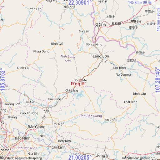
Đồng Mỏ GPS coordinates[2]
21° 39' 25.236" North, 106° 34' 41.952" East
| Map corner | latitude | longitude |
|---|---|---|
| Upper-left | 22.30901°, | 105.8752° |
| Center: | 21.65701°, | 106.57832° |
| Lower-right: | 21.00205°, | 107.28145° |
| Map W x H: | 145.3×145.3 km | = 90.3×90.3mi |
| max Lat: | 23.27841° ⇑12.2% North |
| Đồng Mỏ: | 21.65701° |
| min Lat: | ⇓87.8% South 8.65724° |
| min Long | Đồng Mỏ | max Long |
| 102.4579° | 106.57832° | 112.72541° |
| W 64.6%⇐ | ⇒35.4% E |
Elevation
Elevation of Đồng Mỏ is 65 m = 213 ft, and this is 64.5 m = 212 ft below average elevation for this country.
| Max E: |
1592 m = 5223 ft | 27.9% |
| Avg. | 129.5 m = 425 ft | |
| Đồng Mỏ | 65 m = 213 ft | |
Min E: |
-1 m = -3 ft | 72.1% |
See also: Vietnam elevation on elevation.city.
Geographical zone
Đồng Mỏ is located in North Torrid zone (between Equator and Tropic of Cancer). Distance of this Northern Tropic circle is 197.9 km =123 mi to North.| Distance of | km | miles | from Đồng Mỏ |
|---|---|---|---|
| North Pole | 7599 | 4721.8 | to North |
| Arctic Circle | 4993.1 | 3102.6 | to North |
| Tropic Cancer | 197.9 | 123 | to North |
| Equator | 2408 | 1496.3 | to South |


Nearby cities:
15 places around Đồng Mỏ: (largest is in red/bold)
• An Châu
45.5 km =28.3 mi,  141°
141°
• Bình Gia
40.4 km =25.1 mi,  326°
326°
• Bắc Giang
58.3 km =36.2 mi,  222°
222°
• Bắc Sơn
37.9 km =23.5 mi,  315°
315°
• Cao Thượng
55.3 km =34.4 mi,  237°
237°
• Chũ
31.5 km =19.6 mi,  182°
182°
• Cầu Gồ
50.8 km =31.6 mi,  246°
246°
• Hữu Lũng
29.5 km =18.3 mi, 235°
• Lạng Sơn
28.8 km =17.9 mi,  40°
40°
• Lộc Bình
37.4 km =23.2 mi,  72°
72°
• Thị Trấn Cao Lộc
30.5 km =19 mi, 40°
• Thị Trấn Na Sầm
44.6 km =27.7 mi,  4°
4°
• Văn Quan
23.5 km =14.6 mi,  350°
350°
• Đình Lập
55.1 km =34.2 mi,  102°
102°
• Đồi Ngô
43.7 km =27.2 mi,  206°
206°
Sources, notices
• [Note1] Compared only with cities in Vietnam existing in our database
• [Src1] Map data: © OpenStreetMap contributors (CC-BY-SA)
• [Src2] Other city data from geonames.org with taken over terms of usage.
• [Src3] Geographical zone / Annual Mean Temperature by Robert A. Rohde @ Wikipedia
