Bắc Sơn geodata
Bắc Sơn (Lạng Sơn) is a seat of a second-order administrative division; located in Vietnam in Asia/Ho_Chi_Minh (GMT+7) time zone. In our database, there are 94 cities with bigger population. Compared to other cities in Vietnam, 90.2% of cities are located further ↓South; 56.4% of cities are located further ←West and 86.9% of cities have lower elevation than Bắc Sơn. Note1


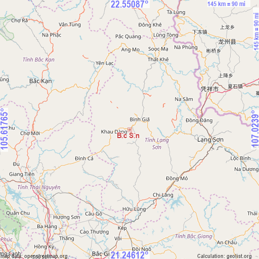
Bắc Sơn GPS coordinates[2]
21° 53' 59.964" North, 106° 19' 14.772" East
| Map corner | latitude | longitude |
|---|---|---|
| Upper-left | 22.55087°, | 105.61765° |
| Center: | 21.89999°, | 106.32077° |
| Lower-right: | 21.24612°, | 107.0239° |
| Map W x H: | 145.1×145.1 km | = 90.2×90.2mi |
| max Lat: | 23.27841° ⇑9.8% North |
| Bắc Sơn: | 21.89999° |
| min Lat: | ⇓90.2% South 8.65724° |
| min Long | Bắc Sơn | max Long |
| 102.4579° | 106.32077° | 112.72541° |
| W 56.4%⇐ | ⇒43.6% E |
Elevation
Elevation of Bắc Sơn is 396 m = 1299 ft, and this is 266.5 m = 874 ft above average elevation for this country.
| Max E: |
1592 m = 5223 ft | 13.1% |
| Bắc Sơn | 396 m 1299 ft | |
| Avg. | 129.5 m = 425 ft | |
Min E: |
-1 m = -3 ft | 86.9% |
See also: Vietnam elevation on elevation.city.
Geographical zone
Bắc Sơn is located in North Torrid zone (between Equator and Tropic of Cancer). Distance of this Northern Tropic circle is 170.9 km =106.2 mi to North.| Distance of | km | miles | from Bắc Sơn |
|---|---|---|---|
| North Pole | 7572 | 4705 | to North |
| Arctic Circle | 4966.1 | 3085.8 | to North |
| Tropic Cancer | 170.9 | 106.2 | to North |
| Equator | 2435.1 | 1513.1 | to South |


Nearby cities:
15 places around Bắc Sơn: (largest is in red/bold)
• Bình Gia
8.1 km =5 mi,  33°
33°
• Bắc Kạn
57.1 km =35.5 mi,  298°
298°
• Chùa Hang
58.2 km =36.2 mi,  238°
238°
• Chợ Mới
56.6 km =35.2 mi,  268°
268°
• Cầu Gồ
51.2 km =31.8 mi,  203°
203°
• Hữu Lũng
43.9 km =27.3 mi,  176°
176°
• Lạng Sơn
45.7 km =28.4 mi,  96°
96°
• Thái Nguyên
59.5 km =37 mi, 235°
• Thị Trấn Cao Lộc
46.3 km =28.8 mi,  94°
94°
• Thị Trấn Na Sầm
35 km =21.7 mi,  60°
60°
• Thị Trấn Thất Khê
42.5 km =26.4 mi,  21°
21°
• Thị Trấn Đông Khê
60 km =37.3 mi,  11°
11°
• Văn Quan
22.9 km =14.2 mi, 99°
• Yến Lạc
40.1 km =24.9 mi,  339°
339°
• Đồng Mỏ
37.9 km =23.5 mi,  135°
135°
Sources, notices
• [Note1] Compared only with cities in Vietnam existing in our database
• [Src1] Map data: © OpenStreetMap contributors (CC-BY-SA)
• [Src2] Other city data from geonames.org with taken over terms of usage.
• [Src3] Geographical zone / Annual Mean Temperature by Robert A. Rohde @ Wikipedia
