Hương Trà geodata
Hương Trà (Thừa Thiên-Huế) is a seat of a second-order administrative division; located in Vietnam in Asia/Ho_Chi_Minh (GMT+7) time zone. In our database, there are 94 cities with bigger population. Compared to other cities in Vietnam, 50.9% of cities are located further ↑North; 78.8% of cities are located further ←West and 58.1% of cities have higher elevation than Hương Trà. Note1


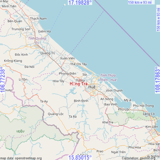
Hương Trà GPS coordinates[2]
16° 31' 31.404" North, 107° 28' 31.8" East
| Map corner | latitude | longitude |
|---|---|---|
| Upper-left | 17.19828°, | 106.77238° |
| Center: | 16.52539°, | 107.4755° |
| Lower-right: | 15.85015°, | 108.17863° |
| Map W x H: | 149.9×149.9 km | = 93.1×93.1mi |
| max Lat: | 23.27841° ⇑50.9% North |
| Hương Trà: | 16.52539° |
| min Lat: | ⇓49.1% South 8.65724° |
| min Long | Hương Trà | max Long |
| 102.4579° | 107.4755° | 112.72541° |
| W 78.8%⇐ | ⇒21.2% E |
Elevation
Elevation of Hương Trà is 11 m = 36 ft, and this is 118.5 m = 389 ft below average elevation for this country.
| Max E: |
1592 m = 5223 ft | 58.1% |
| Avg. | 129.5 m = 425 ft | |
| Hương Trà | 11 m = 36 ft | |
Min E: |
-1 m = -3 ft | 41.9% |
See also: Vietnam elevation on elevation.city.
Geographical zone
Hương Trà is located in North Torrid zone (between Equator and Tropic of Cancer). Distance of this Northern Tropic circle is 768.5 km =477.5 mi to North.| Distance of | km | miles | from Hương Trà |
|---|---|---|---|
| North Pole | 8169.6 | 5076.4 | to North |
| Arctic Circle | 5563.7 | 3457.1 | to North |
| Tropic Cancer | 768.5 | 477.5 | to North |
| Equator | 1837.5 | 1141.8 | to South |


Nearby cities:
15 places around Hương Trà: (largest is in red/bold)
• A Lưới
38.2 km =23.7 mi,  222°
222°
• Cam Lộ
60.1 km =37.3 mi,  301°
301°
• Gio Linh
60.9 km =37.8 mi,  316°
316°
• Huế
14.6 km =9.1 mi,  118°
118°
• Hải Lăng
30.3 km =18.8 mi,  308°
308°
• Hồ Xá
78.4 km =48.7 mi, 320°
• Khe Tre
47.3 km =29.4 mi,  146°
146°
• Krông Klang
65.3 km =40.6 mi,  286°
286°
• Phong Điền
13.5 km =8.4 mi, 298°
• Phú Lộc
49.1 km =30.5 mi, 123°
• Phú Vang
27.2 km =16.9 mi,  110°
110°
• Prao
69.3 km =43.1 mi,  164°
164°
• Sịa
6.6 km =4.1 mi,  34°
34°
• Ái Tử
42.7 km =26.5 mi, 309°
• Ðông Hà
51.4 km =31.9 mi, 308°
Sources, notices
• [Note1] Compared only with cities in Vietnam existing in our database
• [Src1] Map data: © OpenStreetMap contributors (CC-BY-SA)
• [Src2] Other city data from geonames.org with taken over terms of usage.
• [Src3] Geographical zone / Annual Mean Temperature by Robert A. Rohde @ Wikipedia
