Huế geodata
Huế (Thừa Thiên-Huế) is a seat of a first-order administrative division; located in Vietnam in Asia/Ho_Chi_Minh (GMT+7) time zone. With population of 287,217 people, there are 5 cities with bigger population in this country. Compared to other cities in Vietnam, 51.1% of cities are located further ↑North; 79.6% of cities are located further ←West and 71.9% of cities have higher elevation than Huế. Note1


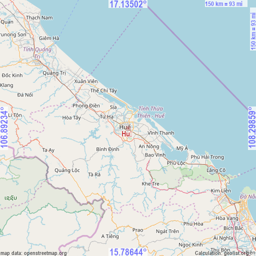
Huế GPS coordinates[2]
16° 27' 42.84" North, 107° 35' 43.656" East
| Map corner | latitude | longitude |
|---|---|---|
| Upper-left | 17.13502°, | 106.89234° |
| Center: | 16.4619°, | 107.59546° |
| Lower-right: | 15.78644°, | 108.29859° |
| Map W x H: | 149.9×150 km | = 93.1×93.2mi |
| max Lat: | 23.27841° ⇑51.1% North |
| Huế: | 16.4619° |
| min Lat: | ⇓48.9% South 8.65724° |
| min Long | Huế | max Long |
| 102.4579° | 107.59546° | 112.72541° |
| W 79.6%⇐ | ⇒20.4% E |
Elevation
Elevation of Huế is 8 m = 26 ft, and this is 121.5 m = 399 ft below average elevation for this country.
| Max E: |
1592 m = 5223 ft | 71.9% |
| Avg. | 129.5 m = 425 ft | |
| Huế | 8 m = 26 ft | |
Min E: |
-1 m = -3 ft | 28.1% |
See also: Huế elevation on elevation.city.
Geographical zone
Huế is located in North Torrid zone (between Equator and Tropic of Cancer). Distance of this Northern Tropic circle is 775.5 km =481.9 mi to North.| Distance of | km | miles | from Huế |
|---|---|---|---|
| North Pole | 8176.7 | 5080.8 | to North |
| Arctic Circle | 5570.8 | 3461.5 | to North |
| Tropic Cancer | 775.5 | 481.9 | to North |
| Equator | 1830.4 | 1137.4 | to South |


Nearby cities:
15 places around Huế: (largest is in red/bold)
• A Lưới
44 km =27.3 mi,  241°
241°
• Cam Lộ
74.7 km =46.4 mi,  300°
300°
• Gio Linh
74.9 km =46.5 mi,  313°
313°
• Hương Trà
14.6 km =9.1 mi, 298°
• Hải Lăng
44.8 km =27.8 mi, 305°
• Khe Tre
35.1 km =21.8 mi,  158°
158°
• Liên Chiểu
74 km =46 mi,  125°
125°
• Phong Điền
28.1 km =17.5 mi, 298°
• Phú Lộc
34.6 km =21.5 mi, 125°
• Phú Vang
12.9 km =8 mi,  101°
101°
• Prao
60 km =37.3 mi,  174°
174°
• Sịa
15.4 km =9.6 mi,  324°
324°
• Thanh Khê
77 km =47.8 mi,  124°
124°
• Ái Tử
57.2 km =35.5 mi, 306°
• Ðông Hà
65.8 km =40.9 mi, 306°
In other languages:
- In Spanish: Hué
- In France: Hué
- In Italian: Hué
- In Russian: Хюэ
- In Chinese: 順化市, 順化
Sources, notices
• [Note1] Compared only with cities in Vietnam existing in our database
• [Src1] Map data: © OpenStreetMap contributors (CC-BY-SA)
• [Src2] Other city data from geonames.org with taken over terms of usage.
• [Src3] Geographical zone / Annual Mean Temperature by Robert A. Rohde @ Wikipedia
