Phong Điền geodata
Phong Điền (Thừa Thiên-Huế) is a seat of a second-order administrative division; located in Vietnam in Asia/Ho_Chi_Minh (GMT+7) time zone. In our database, there are 94 cities with bigger population. Compared to other cities in Vietnam, 50.6% of cities are located further ↑North; 78% of cities are located further ←West and 50.4% of cities have higher elevation than Phong Điền. Note1


Phong Điền GPS coordinates[2]
16° 34' 59.556" North, 107° 21' 51.768" East
| Map corner | latitude | longitude |
|---|---|---|
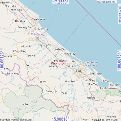
| Upper-left | 17.2559°, | 106.66126° |
| Center: | 16.58321°, | 107.36438° |
| Lower-right: | 15.90816°, | 108.06751° |
| Map W x H: | 149.9×149.9 km | = 93.1×93.1mi |
| max Lat: | 23.27841° ⇑50.6% North |
| Phong Điền: | 16.58321° |
| min Lat: | ⇓49.4% South 8.65724° |
| min Long | Phong Điền | max Long |
| 102.4579° | 107.36438° | 112.72541° |
| W 78%⇐ | ⇒22% E |
Elevation
Elevation of Phong Điền is 14 m = 46 ft, and this is 115.5 m = 379 ft below average elevation for this country.
| Max E: |
1592 m = 5223 ft | 50.4% |
| Avg. | 129.5 m = 425 ft | |
| Phong Điền | 14 m = 46 ft | |
Min E: |
-1 m = -3 ft | 49.6% |
See also: Vietnam elevation on elevation.city.
Geographical zone
Phong Điền is located in North Torrid zone (between Equator and Tropic of Cancer). Distance of this Northern Tropic circle is 762 km =473.5 mi to North.| Distance of | km | miles | from Phong Điền |
|---|---|---|---|
| North Pole | 8163.2 | 5072.4 | to North |
| Arctic Circle | 5557.3 | 3453.1 | to North |
| Tropic Cancer | 762 | 473.5 | to North |
| Equator | 1843.9 | 1145.7 | to South |


Nearby cities:
15 places around Phong Điền: (largest is in red/bold)
• A Lưới
37.3 km =23.2 mi,  201°
201°
• Cam Lộ
46.7 km =29 mi,  302°
302°
• Gio Linh
48.3 km =30 mi,  321°
321°
• Huế
28.1 km =17.5 mi,  118°
118°
• Hương Trà
13.5 km =8.4 mi, 118°
• Hải Lăng
17.2 km =10.7 mi, 315°
• Hồ Xá
66.1 km =41.1 mi, 324°
• Khe Sanh
66.8 km =41.5 mi,  274°
274°
• Khe Tre
59.5 km =37 mi,  140°
140°
• Krông Klang
52.2 km =32.4 mi,  283°
283°
• Phú Lộc
62.6 km =38.9 mi, 122°
• Phú Vang
40.6 km =25.2 mi,  113°
113°
• Sịa
15.6 km =9.7 mi,  93°
93°
• Ái Tử
29.6 km =18.4 mi,  314°
314°
• Ðông Hà
38.2 km =23.7 mi, 312°
Sources, notices
• [Note1] Compared only with cities in Vietnam existing in our database
• [Src1] Map data: © OpenStreetMap contributors (CC-BY-SA)
• [Src2] Other city data from geonames.org with taken over terms of usage.
• [Src3] Geographical zone / Annual Mean Temperature by Robert A. Rohde @ Wikipedia
