Phú Vang geodata
Phú Vang (Thừa Thiên-Huế) is a seat of a second-order administrative division; located in Vietnam in Asia/Ho_Chi_Minh (GMT+7) time zone. In our database, there are 94 cities with bigger population. Compared to other cities in Vietnam, 51.2% of cities are located further ↑North; 80.9% of cities are located further ←West and 71.9% of cities have higher elevation than Phú Vang. Note1


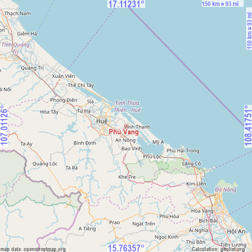
Phú Vang GPS coordinates[2]
16° 26' 20.796" North, 107° 42' 51.768" East
| Map corner | latitude | longitude |
|---|---|---|
| Upper-left | 17.11231°, | 107.01126° |
| Center: | 16.43911°, | 107.71438° |
| Lower-right: | 15.76357°, | 108.41751° |
| Map W x H: | 150×150 km | = 93.2×93.2mi |
| max Lat: | 23.27841° ⇑51.2% North |
| Phú Vang: | 16.43911° |
| min Lat: | ⇓48.8% South 8.65724° |
| min Long | Phú Vang | max Long |
| 102.4579° | 107.71438° | 112.72541° |
| W 80.9%⇐ | ⇒19.1% E |
Elevation
Elevation of Phú Vang is 8 m = 26 ft, and this is 121.5 m = 399 ft below average elevation for this country.
| Max E: |
1592 m = 5223 ft | 71.9% |
| Avg. | 129.5 m = 425 ft | |
| Phú Vang | 8 m = 26 ft | |
Min E: |
-1 m = -3 ft | 28.1% |
See also: Vietnam elevation on elevation.city.
Geographical zone
Phú Vang is located in North Torrid zone (between Equator and Tropic of Cancer). Distance of this Northern Tropic circle is 778.1 km =483.5 mi to North.| Distance of | km | miles | from Phú Vang |
|---|---|---|---|
| North Pole | 8179.2 | 5082.3 | to North |
| Arctic Circle | 5573.3 | 3463.1 | to North |
| Tropic Cancer | 778.1 | 483.5 | to North |
| Equator | 1827.9 | 1135.8 | to South |


Nearby cities:
15 places around Phú Vang: (largest is in red/bold)
• A Lưới
54.5 km =33.9 mi,  250°
250°
• Da Nang
68 km =42.3 mi,  127°
127°
• Huế
12.9 km =8 mi,  281°
281°
• Hòa Vang
67.6 km =42 mi,  137°
137°
• Hương Trà
27.2 km =16.9 mi,  290°
290°
• Hải Lăng
56.9 km =35.4 mi,  299°
299°
• Khe Tre
30 km =18.6 mi,  179°
179°
• Liên Chiểu
62.5 km =38.8 mi, 130°
• Phong Điền
40.6 km =25.2 mi, 293°
• Phú Lộc
23.4 km =14.5 mi, 138°
• Prao
57.7 km =35.9 mi,  187°
187°
• Sơn Trà
69.5 km =43.2 mi, 127°
• Sịa
26.4 km =16.4 mi, 304°
• Thanh Khê
65.3 km =40.6 mi, 128°
• Ái Tử
69.1 km =42.9 mi, 302°
Sources, notices
• [Note1] Compared only with cities in Vietnam existing in our database
• [Src1] Map data: © OpenStreetMap contributors (CC-BY-SA)
• [Src2] Other city data from geonames.org with taken over terms of usage.
• [Src3] Geographical zone / Annual Mean Temperature by Robert A. Rohde @ Wikipedia
