Thị Trấn Đồng Văn geodata
Thị Trấn Đồng Văn (Hà Giang) is a seat of a second-order administrative division; located in Vietnam in Asia/Ho_Chi_Minh (GMT+7) time zone. In our database, there are 94 cities with bigger population. Compared to other cities in Vietnam, 100% of cities are located further ↓South; 81.2% of cities are located further →East and 98.9% of cities have lower elevation than Thị Trấn Đồng Văn. Note1


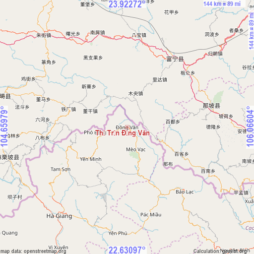
Thị Trấn Đồng Văn GPS coordinates[2]
23° 16' 42.276" North, 105° 21' 46.476" East
| Map corner | latitude | longitude |
|---|---|---|
| Upper-left | 23.92272°, | 104.65979° |
| Center: | 23.27841°, | 105.36291° |
| Lower-right: | 22.63097°, | 106.06604° |
| Map W x H: | 143.6×143.6 km | = 89.2×89.2mi |
| max Lat: | 23.27841° ⇑0% North |
| Thị Trấn Đồng Văn: | 23.27841° |
| min Lat: | ⇓100% South 8.65724° |
| min Long | Thị Trấn Đ | max Long |
| 102.4579° | 105.36291° | 112.72541° |
| W 18.8%⇐ | ⇒81.2% E |
Elevation
Elevation of Thị Trấn Đồng Văn is 1068 m = 3504 ft, and this is 938.5 m = 3079 ft above average elevation for this country.
| Max E: |
1592 m = 5223 ft | 1.1% |
| Thị Trấn Đồng Văn | 1068 m 3504 ft | |
| Avg. | 129.5 m = 425 ft | |
Min E: |
-1 m = -3 ft | 98.9% |
See also: Vietnam elevation on elevation.city.
Geographical zone
Thị Trấn Đồng Văn is located in North Torrid zone (between Equator and Tropic of Cancer). Distance of this Northern Tropic circle is 17.6 km =10.9 mi to North.| Distance of | km | miles | from Thị Trấn Đồng Văn |
|---|---|---|---|
| North Pole | 7418.7 | 4609.8 | to North |
| Arctic Circle | 4812.9 | 2990.6 | to North |
| Tropic Cancer | 17.6 | 10.9 | to North |
| Equator | 2588.3 | 1608.3 | to South |


Nearby cities:
15 places around Thị Trấn Đồng Văn: (largest is in red/bold)
• Bộc Bố
80.4 km =50 mi,  157°
157°
• Hà Giang
63.8 km =39.6 mi,  217°
217°
• Lũng Hồ
35 km =21.7 mi,  201°
201°
• Pác Miầu
51.6 km =32.1 mi,  165°
165°
• Thị Trấn Bảo Lạc
48.9 km =30.4 mi,  138°
138°
• Thị Trấn Mèo Vạc
13.6 km =8.5 mi, 159°
• Thị Trấn Tam Sơn
44.8 km =27.8 mi,  238°
238°
• Thị Trấn Thông Nông
84 km =52.2 mi,  130°
130°
• Thị Trấn Vinh Quang
92 km =57.2 mi,  229°
229°
• Thị Trấn Việt Lâm
83.6 km =51.9 mi,  209°
209°
• Thị Trấn Vị Xuyên
78.3 km =48.7 mi, 209°
• Thị Trấn Xuân Hoà
84.2 km =52.3 mi,  119°
119°
• Thị Trấn Yên Minh
28.8 km =17.9 mi, 231°
• Tân Việt
47.1 km =29.3 mi, 167°
• Yên Phú
60.7 km =37.7 mi,  179°
179°
Sources, notices
• [Note1] Compared only with cities in Vietnam existing in our database
• [Src1] Map data: © OpenStreetMap contributors (CC-BY-SA)
• [Src2] Other city data from geonames.org with taken over terms of usage.
• [Src3] Geographical zone / Annual Mean Temperature by Robert A. Rohde @ Wikipedia
