Lũng Hồ geodata
Lũng Hồ (Hà Giang) is a seat of a third-order administrative division; located in Vietnam in Asia/Ho_Chi_Minh (GMT+7) time zone. In our database, there are 94 cities with bigger population. Compared to other cities in Vietnam, 99.3% of cities are located further ↓South; 85% of cities are located further →East and 94.1% of cities have lower elevation than Lũng Hồ. Note1


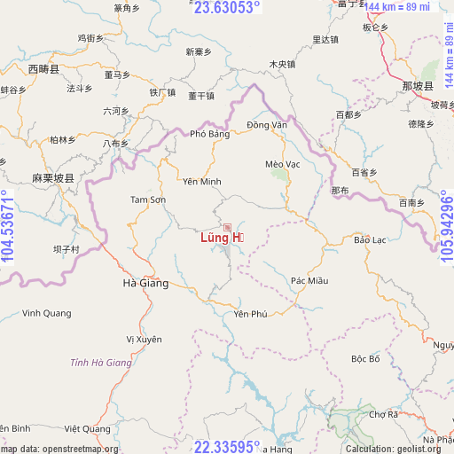
Lũng Hồ GPS coordinates[2]
22° 59' 5.244" North, 105° 14' 23.388" East
| Map corner | latitude | longitude |
|---|---|---|
| Upper-left | 23.63053°, | 104.53671° |
| Center: | 22.98479°, | 105.23983° |
| Lower-right: | 22.33595°, | 105.94296° |
| Map W x H: | 143.9×143.9 km | = 89.4×89.4mi |
| max Lat: | 23.27841° ⇑0.7% North |
| Lũng Hồ: | 22.98479° |
| min Lat: | ⇓99.3% South 8.65724° |
| min Long | Lũng Hồ | max Long |
| 102.4579° | 105.23983° | 112.72541° |
| W 15%⇐ | ⇒85% E |
Elevation
Elevation of Lũng Hồ is 646 m = 2119 ft, and this is 516.5 m = 1695 ft above average elevation for this country.
| Max E: |
1592 m = 5223 ft | 5.9% |
| Lũng Hồ | 646 m 2119 ft | |
| Avg. | 129.5 m = 425 ft | |
Min E: |
-1 m = -3 ft | 94.1% |
See also: Vietnam elevation on elevation.city.
Geographical zone
Lũng Hồ is located in North Torrid zone (between Equator and Tropic of Cancer). Distance of this Northern Tropic circle is 50.2 km =31.2 mi to North.| Distance of | km | miles | from Lũng Hồ |
|---|---|---|---|
| North Pole | 7451.4 | 4630.1 | to North |
| Arctic Circle | 4845.5 | 3010.9 | to North |
| Tropic Cancer | 50.2 | 31.2 | to North |
| Equator | 2555.7 | 1588 | to South |


Nearby cities:
15 places around Lũng Hồ: (largest is in red/bold)
• Bộc Bố
60.3 km =37.5 mi,  133°
133°
• Hà Giang
31.8 km =19.8 mi,  235°
235°
• Pác Miầu
31.2 km =19.4 mi,  123°
123°
• Thị Trấn Bảo Lạc
45.3 km =28.1 mi,  95°
95°
• Thị Trấn Mèo Vạc
26.5 km =16.5 mi,  41°
41°
• Thị Trấn Na Hang
72.2 km =44.9 mi,  168°
168°
• Thị Trấn Tam Sơn
27.2 km =16.9 mi,  289°
289°
• Thị Trấn Vinh Quang
63.5 km =39.5 mi, 244°
• Thị Trấn Việt Lâm
49.2 km =30.6 mi,  215°
215°
• Thị Trấn Việt Quang
77.4 km =48.1 mi, 215°
• Thị Trấn Vị Xuyên
44.1 km =27.4 mi, 216°
• Thị Trấn Yên Minh
17.9 km =11.1 mi,  325°
325°
• Thị Trấn Đồng Văn
35 km =21.7 mi,  21°
21°
• Tân Việt
26.2 km =16.3 mi, 120°
• Yên Phú
31.2 km =19.4 mi,  154°
154°
Sources, notices
• [Note1] Compared only with cities in Vietnam existing in our database
• [Src1] Map data: © OpenStreetMap contributors (CC-BY-SA)
• [Src2] Other city data from geonames.org with taken over terms of usage.
• [Src3] Geographical zone / Annual Mean Temperature by Robert A. Rohde @ Wikipedia
