Hà Giang geodata
Hà Giang is a seat of a first-order administrative division; located in Vietnam in Asia/Ho_Chi_Minh (GMT+7) time zone. With population of 32,690 people, there are 73 cities with bigger population in this country. Compared to other cities in Vietnam, 98.2% of cities are located further ↓South; 90% of cities are located further →East and 75.2% of cities have lower elevation than Hà Giang. Note1


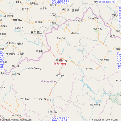
Hà Giang GPS coordinates[2]
22° 49' 23.988" North, 104° 59' 0.852" East
| Map corner | latitude | longitude |
|---|---|---|
| Upper-left | 23.46985°, | 104.28045° |
| Center: | 22.82333°, | 104.98357° |
| Lower-right: | 22.17372°, | 105.6867° |
| Map W x H: | 144.1×144.1 km | = 89.5×89.5mi |
| max Lat: | 23.27841° ⇑1.8% North |
| Hà Giang: | 22.82333° |
| min Lat: | ⇓98.2% South 8.65724° |
| min Long | Hà Giang | max Long |
| 102.4579° | 104.98357° | 112.72541° |
| W 10%⇐ | ⇒90% E |
Elevation
Elevation of Hà Giang is 107 m = 351 ft, and this is 22.5 m = 74 ft below average elevation for this country.
| Max E: |
1592 m = 5223 ft | 24.8% |
| Avg. | 129.5 m = 425 ft | |
| Hà Giang | 107 m = 351 ft | |
Min E: |
-1 m = -3 ft | 75.2% |
See also: Vietnam elevation on elevation.city.
Geographical zone
Hà Giang is located in North Torrid zone (between Equator and Tropic of Cancer). Distance of this Northern Tropic circle is 68.2 km =42.4 mi to North.| Distance of | km | miles | from Hà Giang |
|---|---|---|---|
| North Pole | 7469.3 | 4641.2 | to North |
| Arctic Circle | 4863.5 | 3022 | to North |
| Tropic Cancer | 68.2 | 42.4 | to North |
| Equator | 2537.7 | 1576.9 | to South |


Nearby cities:
15 places around Hà Giang: (largest is in red/bold)
• Lũng Hồ
31.8 km =19.8 mi,  55°
55°
• Pác Miầu
52.2 km =32.4 mi,  89°
89°
• Thị Trấn Mèo Vạc
57.8 km =35.9 mi,  49°
49°
• Thị Trấn Na Hang
66.8 km =41.5 mi,  142°
142°
• Thị Trấn Tam Sơn
27.1 km =16.8 mi,  1°
1°
• Thị Trấn Vinh Quang
32.5 km =20.2 mi,  253°
253°
• Thị Trấn Việt Lâm
22.2 km =13.8 mi,  186°
186°
• Thị Trấn Việt Quang
48.9 km =30.4 mi,  201°
201°
• Thị Trấn Vĩnh Tuy
61.8 km =38.4 mi, 188°
• Thị Trấn Vị Xuyên
17.3 km =10.7 mi,  180°
180°
• Thị Trấn Yên Minh
36.5 km =22.7 mi,  26°
26°
• Thị Trấn Đồng Văn
63.8 km =39.6 mi,  37°
37°
• Tân Việt
48.9 km =30.4 mi,  84°
84°
• Yên Bình
61.9 km =38.5 mi,  222°
222°
• Yên Phú
41 km =25.5 mi,  104°
104°
Sources, notices
• [Note1] Compared only with cities in Vietnam existing in our database
• [Src1] Map data: © OpenStreetMap contributors (CC-BY-SA)
• [Src2] Other city data from geonames.org with taken over terms of usage.
• [Src3] Geographical zone / Annual Mean Temperature by Robert A. Rohde @ Wikipedia
