Tân Việt geodata
Tân Việt (Cao Bằng) is a seat of a third-order administrative division; located in Vietnam in Asia/Ho_Chi_Minh (GMT+7) time zone. In our database, there are 94 cities with bigger population. Compared to other cities in Vietnam, 98.9% of cities are located further ↓South; 78.1% of cities are located further →East and 86% of cities have lower elevation than Tân Việt. Note1


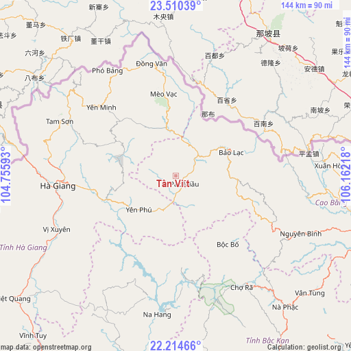
Tân Việt GPS coordinates[2]
22° 51' 50.652" North, 105° 27' 32.58" East
| Map corner | latitude | longitude |
|---|---|---|
| Upper-left | 23.51039°, | 104.75593° |
| Center: | 22.86407°, | 105.45905° |
| Lower-right: | 22.21466°, | 106.16218° |
| Map W x H: | 144.1×144.1 km | = 89.5×89.5mi |
| max Lat: | 23.27841° ⇑1.1% North |
| Tân Việt: | 22.86407° |
| min Lat: | ⇓98.9% South 8.65724° |
| min Long | Tân Việt | max Long |
| 102.4579° | 105.45905° | 112.72541° |
| W 21.9%⇐ | ⇒78.1% E |
Elevation
Elevation of Tân Việt is 344 m = 1129 ft, and this is 214.5 m = 704 ft above average elevation for this country.
| Max E: |
1592 m = 5223 ft | 14% |
| Tân Việt | 344 m 1129 ft | |
| Avg. | 129.5 m = 425 ft | |
Min E: |
-1 m = -3 ft | 86% |
See also: Vietnam elevation on elevation.city.
Geographical zone
Tân Việt is located in North Torrid zone (between Equator and Tropic of Cancer). Distance of this Northern Tropic circle is 63.7 km =39.6 mi to North.| Distance of | km | miles | from Tân Việt |
|---|---|---|---|
| North Pole | 7464.8 | 4638.4 | to North |
| Arctic Circle | 4858.9 | 3019.2 | to North |
| Tropic Cancer | 63.7 | 39.6 | to North |
| Equator | 2542.2 | 1579.6 | to South |


Nearby cities:
15 places around Tân Việt: (largest is in red/bold)
• Bộc Bố
35.2 km =21.9 mi,  142°
142°
• Hà Giang
48.9 km =30.4 mi,  264°
264°
• Lũng Hồ
26.2 km =16.3 mi,  300°
300°
• Pác Miầu
5.2 km =3.2 mi, 137°
• Thị Trấn Bảo Lạc
24.6 km =15.3 mi,  67°
67°
• Thị Trấn Mèo Vạc
33.7 km =20.9 mi,  351°
351°
• Thị Trấn Na Hang
57.8 km =35.9 mi,  187°
187°
• Thị Trấn Nguyên Bình
56.6 km =35.2 mi,  114°
114°
• Thị Trấn Tam Sơn
53.1 km =33 mi, 295°
• Thị Trấn Thông Nông
54.4 km =33.8 mi,  99°
99°
• Thị Trấn Việt Lâm
57.7 km =35.9 mi,  242°
242°
• Thị Trấn Vị Xuyên
53.6 km =33.3 mi,  245°
245°
• Thị Trấn Yên Minh
43 km =26.7 mi,  310°
310°
• Thị Trấn Đồng Văn
47.1 km =29.3 mi, 347°
• Yên Phú
17.2 km =10.7 mi,  211°
211°
Sources, notices
• [Note1] Compared only with cities in Vietnam existing in our database
• [Src1] Map data: © OpenStreetMap contributors (CC-BY-SA)
• [Src2] Other city data from geonames.org with taken over terms of usage.
• [Src3] Geographical zone / Annual Mean Temperature by Robert A. Rohde @ Wikipedia
