Củ Chi geodata
Củ Chi (Ho Chi Minh) is a seat of a second-order administrative division; located in Vietnam in Asia/Ho_Chi_Minh (GMT+7) time zone. With population of 75,000 people, there are 42 cities with bigger population in this country. Compared to other cities in Vietnam, 74.7% of cities are located further ↑North; 62.2% of cities are located further ←West and 50.4% of cities have higher elevation than Củ Chi. Note1


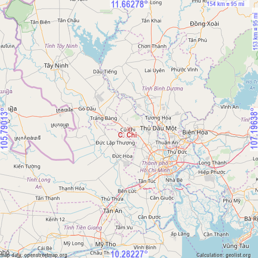
Củ Chi GPS coordinates[2]
10° 58' 23.988" North, 106° 29' 35.7" East
| Map corner | latitude | longitude |
|---|---|---|
| Upper-left | 11.66278°, | 105.79013° |
| Center: | 10.97333°, | 106.49325° |
| Lower-right: | 10.28227°, | 107.19638° |
| Map W x H: | 153.5×153.5 km | = 95.4×95.4mi |
| max Lat: | 23.27841° ⇑74.7% North |
| Củ Chi: | 10.97333° |
| min Lat: | ⇓25.3% South 8.65724° |
| min Long | Củ Chi | max Long |
| 102.4579° | 106.49325° | 112.72541° |
| W 62.2%⇐ | ⇒37.8% E |
Elevation
Elevation of Củ Chi is 14 m = 46 ft, and this is 115.5 m = 379 ft below average elevation for this country.
| Max E: |
1592 m = 5223 ft | 50.4% |
| Avg. | 129.5 m = 425 ft | |
| Củ Chi | 14 m = 46 ft | |
Min E: |
-1 m = -3 ft | 49.6% |
See also: Củ Chi elevation on elevation.city.
Geographical zone
Củ Chi is located in North Torrid zone (between Equator and Tropic of Cancer). Distance of Equator is 1220.1 km =758.1 mi to South.| Distance of | km | miles | from Củ Chi |
|---|---|---|---|
| North Pole | 8786.9 | 5459.9 | to North |
| Arctic Circle | 6181.1 | 3840.8 | to North |
| Tropic Cancer | 1385.8 | 861.1 | to North |
| Equator | 1220.1 | 758.1 | to South |


Nearby cities:
15 places around Củ Chi: (largest is in red/bold)
• Gò Dầu
28.2 km =17.5 mi,  297°
297°
• Ho Chi Minh City
22.4 km =13.9 mi,  138°
138°
• Hóc Môn
14.6 km =9.1 mi,  130°
130°
• Hậu Nghĩa
13.7 km =8.5 mi,  230°
230°
• Lái Thiêu
23.8 km =14.8 mi,  108°
108°
• Quận Ba
30.5 km =19 mi, 136°
• Quận Bình Thạnh
29.2 km =18.1 mi, 130°
• Quận Mười
29.6 km =18.4 mi, 140°
• Quận Mười Một
28.5 km =17.7 mi, 144°
• Quận Phú Nhuận
28.2 km =17.5 mi, 134°
• Quận Sáu
30.4 km =18.9 mi,  145°
145°
• Quận Tân Phú
26.3 km =16.3 mi, 143°
• Thủ Dầu Một
17.3 km =10.7 mi,  87°
87°
• Trảng Bàng
16.1 km =10 mi,  292°
292°
• Đông Thành
22.3 km =13.9 mi,  246°
246°
Sources, notices
• [Note1] Compared only with cities in Vietnam existing in our database
• [Src1] Map data: © OpenStreetMap contributors (CC-BY-SA)
• [Src2] Other city data from geonames.org with taken over terms of usage.
• [Src3] Geographical zone / Annual Mean Temperature by Robert A. Rohde @ Wikipedia
