Thị Trấn Tân Thành geodata
Thị Trấn Tân Thành (Đồng Tháp) is a populated place; located in Vietnam in Asia/Ho_Chi_Minh (GMT+7) time zone. With population of 23,109 people, there are 80 cities with bigger population in this country. Compared to other cities in Vietnam, 88.6% of cities are located further ↑North; 73.6% of cities are located further →East and 99.2% of cities have higher elevation than Thị Trấn Tân Thành. Note1


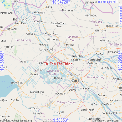
Thị Trấn Tân Thành GPS coordinates[2]
10° 15' 22.176" North, 105° 35' 34.08" East
| Map corner | latitude | longitude |
|---|---|---|
| Upper-left | 10.94728°, | 104.88968° |
| Center: | 10.25616°, | 105.5928° |
| Lower-right: | 9.56353°, | 106.29593° |
| Map W x H: | 153.9×153.9 km | = 95.6×95.6mi |
| max Lat: | 23.27841° ⇑88.6% North |
| Thị Trấn Tân Thành: | 10.25616° |
| min Lat: | ⇓11.4% South 8.65724° |
| min Long | Thị Trấn T� | max Long |
| 102.4579° | 105.5928° | 112.72541° |
| W 26.4%⇐ | ⇒73.6% E |
Elevation
Elevation of Thị Trấn Tân Thành is 1 m = 3 ft, and this is 128.5 m = 422 ft below average elevation for this country.
| Max E: |
1592 m = 5223 ft | 99.2% |
| Avg. | 129.5 m = 425 ft | |
| Thị Trấn Tân Thành | 1 m = 3 ft | |
Min E: |
-1 m = -3 ft | 0.8% |
See also: Vietnam elevation on elevation.city.
Geographical zone
Thị Trấn Tân Thành is located in North Torrid zone (between Equator and Tropic of Cancer). Distance of Equator is 1140.4 km =708.6 mi to South.| Distance of | km | miles | from Thị Trấn Tân Thành |
|---|---|---|---|
| North Pole | 8866.7 | 5509.5 | to North |
| Arctic Circle | 6260.8 | 3890.3 | to North |
| Tropic Cancer | 1465.5 | 910.6 | to North |
| Equator | 1140.4 | 708.6 | to South |


Nearby cities:
15 places around Thị Trấn Tân Thành: (largest is in red/bold)
• An Hòa
17.2 km =10.7 mi,  74°
74°
• Bình Thủy
25.8 km =16 mi,  141°
141°
• Cao Lãnh
23.1 km =14.4 mi,  10°
10°
• Cái Tàu Hạ
30.4 km =18.9 mi,  89°
89°
• Cờ Đỏ
25.4 km =15.8 mi,  224°
224°
• Lai Vung
8.3 km =5.2 mi, 65°
• Long Xuyên
22.5 km =14 mi,  310°
310°
• Lấp Vò
14.2 km =8.8 mi,  325°
325°
• Mỹ Thọ
23.6 km =14.7 mi,  28°
28°
• Phong Điền
29.9 km =18.6 mi,  164°
164°
• Sa Dec
18.3 km =11.4 mi,  77°
77°
• Thốt Nốt
6.7 km =4.2 mi,  285°
285°
• Thới Lai
21.6 km =13.4 mi,  189°
189°
• Vĩnh Thạnh
21.6 km =13.4 mi,  260°
260°
• Ô Môn
16.6 km =10.3 mi,  168°
168°
Sources, notices
• [Note1] Compared only with cities in Vietnam existing in our database
• [Src1] Map data: © OpenStreetMap contributors (CC-BY-SA)
• [Src2] Other city data from geonames.org with taken over terms of usage.
• [Src3] Geographical zone / Annual Mean Temperature by Robert A. Rohde @ Wikipedia
