Cầu Kè geodata
Cầu Kè (Trà Vinh) is a seat of a second-order administrative division; located in Vietnam in Asia/Ho_Chi_Minh (GMT+7) time zone. In our database, there are 94 cities with bigger population. Compared to other cities in Vietnam, 93.8% of cities are located further ↑North; 52.5% of cities are located further →East and 98% of cities have higher elevation than Cầu Kè. Note1


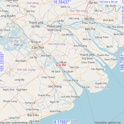
Cầu Kè GPS coordinates[2]
9° 52' 20.64" North, 106° 3' 17.892" East
| Map corner | latitude | longitude |
|---|---|---|
| Upper-left | 10.56437°, | 105.35185° |
| Center: | 9.8724°, | 106.05497° |
| Lower-right: | 9.17897°, | 106.7581° |
| Map W x H: | 154×154 km | = 95.7×95.7mi |
| max Lat: | 23.27841° ⇑93.8% North |
| Cầu Kè: | 9.8724° |
| min Lat: | ⇓6.2% South 8.65724° |
| min Long | Cầu Kè | max Long |
| 102.4579° | 106.05497° | 112.72541° |
| W 47.5%⇐ | ⇒52.5% E |
Elevation
Elevation of Cầu Kè is 2 m = 7 ft, and this is 127.5 m = 418 ft below average elevation for this country.
| Max E: |
1592 m = 5223 ft | 98% |
| Avg. | 129.5 m = 425 ft | |
| Cầu Kè | 2 m = 7 ft | |
Min E: |
-1 m = -3 ft | 2% |
See also: Vietnam elevation on elevation.city.
Geographical zone
Cầu Kè is located in North Torrid zone (between Equator and Tropic of Cancer). Distance of Equator is 1097.7 km =682.1 mi to South.| Distance of | km | miles | from Cầu Kè |
|---|---|---|---|
| North Pole | 8909.4 | 5536 | to North |
| Arctic Circle | 6303.5 | 3916.8 | to North |
| Tropic Cancer | 1508.2 | 937.2 | to North |
| Equator | 1097.7 | 682.1 | to South |


Nearby cities:
15 places around Cầu Kè: (largest is in red/bold)
• Bình Minh
33.5 km =20.8 mi,  310°
310°
• Châu Thành
25.4 km =15.8 mi,  221°
221°
• Châu Thành
32.3 km =20.1 mi,  90°
90°
• Cù Lao Dung
24.4 km =15.2 mi,  155°
155°
• Kế Sách
13.9 km =8.6 mi,  213°
213°
• Long Phú
30 km =18.6 mi,  166°
166°
• Ngã Bảy
26.5 km =16.5 mi,  255°
255°
• Ngã Sáu
27.9 km =17.3 mi,  281°
281°
• Sóc Trăng
31.6 km =19.6 mi,  196°
196°
• Tam Bình
20.4 km =12.7 mi,  342°
342°
• Tiểu Cần
16.3 km =10.1 mi,  114°
114°
• Trà Cú
29.6 km =18.4 mi,  131°
131°
• Trà Vinh
32.5 km =20.2 mi,  75°
75°
• Trà Ôn
17.7 km =11 mi,  304°
304°
• Vũng Liêm
28.7 km =17.8 mi,  29°
29°
Sources, notices
• [Note1] Compared only with cities in Vietnam existing in our database
• [Src1] Map data: © OpenStreetMap contributors (CC-BY-SA)
• [Src2] Other city data from geonames.org with taken over terms of usage.
• [Src3] Geographical zone / Annual Mean Temperature by Robert A. Rohde @ Wikipedia
