Bình Minh geodata
Bình Minh (Vĩnh Long) is a seat of a second-order administrative division; located in Vietnam in Asia/Ho_Chi_Minh (GMT+7) time zone. In our database, there are 94 cities with bigger population. Compared to other cities in Vietnam, 91.4% of cities are located further ↑North; 62.8% of cities are located further →East and 87.1% of cities have higher elevation than Bình Minh. Note1


Bình Minh GPS coordinates[2]
10° 4' 5.556" North, 105° 49' 19.956" East
| Map corner | latitude | longitude |
|---|---|---|
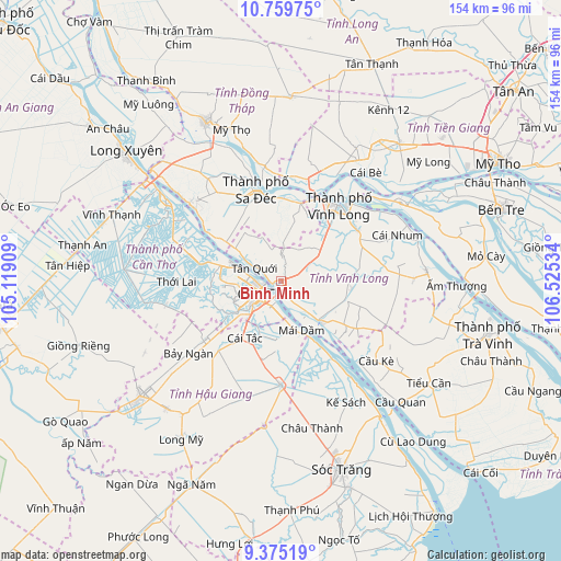
| Upper-left | 10.75975°, | 105.11909° |
| Center: | 10.06821°, | 105.82221° |
| Lower-right: | 9.37519°, | 106.52534° |
| Map W x H: | 153.9×154 km | = 95.6×95.7mi |
| max Lat: | 23.27841° ⇑91.4% North |
| Bình Minh: | 10.06821° |
| min Lat: | ⇓8.6% South 8.65724° |
| min Long | Bình Minh | max Long |
| 102.4579° | 105.82221° | 112.72541° |
| W 37.2%⇐ | ⇒62.8% E |
Elevation
Elevation of Bình Minh is 5 m = 16 ft, and this is 124.5 m = 408 ft below average elevation for this country.
| Max E: |
1592 m = 5223 ft | 87.1% |
| Avg. | 129.5 m = 425 ft | |
| Bình Minh | 5 m = 16 ft | |
Min E: |
-1 m = -3 ft | 12.9% |
See also: Vietnam elevation on elevation.city.
Geographical zone
Bình Minh is located in North Torrid zone (between Equator and Tropic of Cancer). Distance of Equator is 1119.5 km =695.6 mi to South.| Distance of | km | miles | from Bình Minh |
|---|---|---|---|
| North Pole | 8887.6 | 5522.5 | to North |
| Arctic Circle | 6281.7 | 3903.3 | to North |
| Tropic Cancer | 1486.4 | 923.6 | to North |
| Equator | 1119.5 | 695.6 | to South |


Nearby cities:
15 places around Bình Minh: (largest is in red/bold)
• An Hòa
26.8 km =16.7 mi,  341°
341°
• Bình Thủy
9.1 km =5.7 mi,  274°
274°
• Cái Răng
10.8 km =6.7 mi,  226°
226°
• Cái Tàu Hạ
21.9 km =13.6 mi,  13°
13°
• Cần Thơ
5.1 km =3.2 mi, 227°
• Long Hồ
25 km =15.5 mi,  56°
56°
• Một Ngàn
26.5 km =16.5 mi, 232°
• Ngã Bảy
28.3 km =17.6 mi,  180°
180°
• Ngã Sáu
16.2 km =10.1 mi,  186°
186°
• Phong Điền
18.7 km =11.6 mi,  245°
245°
• Sa Dec
25.8 km =16 mi, 343°
• Tam Bình
19.6 km =12.2 mi,  96°
96°
• Trà Ôn
16 km =9.9 mi,  137°
137°
• Vĩnh Long
26.4 km =16.4 mi,  38°
38°
• Ô Môn
22.3 km =13.9 mi,  281°
281°
Sources, notices
• [Note1] Compared only with cities in Vietnam existing in our database
• [Src1] Map data: © OpenStreetMap contributors (CC-BY-SA)
• [Src2] Other city data from geonames.org with taken over terms of usage.
• [Src3] Geographical zone / Annual Mean Temperature by Robert A. Rohde @ Wikipedia
