Trà Ôn geodata
Trà Ôn (Vĩnh Long) is a seat of a second-order administrative division; located in Vietnam in Asia/Ho_Chi_Minh (GMT+7) time zone. In our database, there are 94 cities with bigger population. Compared to other cities in Vietnam, 92.7% of cities are located further ↑North; 58.6% of cities are located further →East and 87.1% of cities have higher elevation than Trà Ôn. Note1


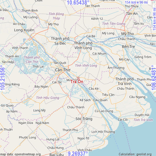
Trà Ôn GPS coordinates[2]
9° 57' 45.396" North, 105° 55' 18.048" East
| Map corner | latitude | longitude |
|---|---|---|
| Upper-left | 10.65438°, | 105.21856° |
| Center: | 9.96261°, | 105.92168° |
| Lower-right: | 9.26937°, | 106.62481° |
| Map W x H: | 154×154 km | = 95.7×95.7mi |
| max Lat: | 23.27841° ⇑92.7% North |
| Trà Ôn: | 9.96261° |
| min Lat: | ⇓7.3% South 8.65724° |
| min Long | Trà Ôn | max Long |
| 102.4579° | 105.92168° | 112.72541° |
| W 41.4%⇐ | ⇒58.6% E |
Elevation
Elevation of Trà Ôn is 5 m = 16 ft, and this is 124.5 m = 408 ft below average elevation for this country.
| Max E: |
1592 m = 5223 ft | 87.1% |
| Avg. | 129.5 m = 425 ft | |
| Trà Ôn | 5 m = 16 ft | |
Min E: |
-1 m = -3 ft | 12.9% |
See also: Vietnam elevation on elevation.city.
Geographical zone
Trà Ôn is located in North Torrid zone (between Equator and Tropic of Cancer). Distance of Equator is 1107.7 km =688.3 mi to South.| Distance of | km | miles | from Trà Ôn |
|---|---|---|---|
| North Pole | 8899.3 | 5529.8 | to North |
| Arctic Circle | 6293.4 | 3910.5 | to North |
| Tropic Cancer | 1498.2 | 930.9 | to North |
| Equator | 1107.7 | 688.3 | to South |


Nearby cities:
15 places around Trà Ôn: (largest is in red/bold)
• Bình Minh
16 km =9.9 mi,  317°
317°
• Bình Thủy
23.5 km =14.6 mi,  301°
301°
• Châu Thành
29.2 km =18.1 mi,  184°
184°
• Cái Nhum
31.3 km =19.4 mi,  41°
41°
• Cái Răng
19.2 km =11.9 mi,  282°
282°
• Cần Thơ
16.8 km =10.4 mi, 299°
• Cầu Kè
17.7 km =11 mi,  124°
124°
• Kế Sách
22.8 km =14.2 mi,  162°
162°
• Long Hồ
27.5 km =17.1 mi,  21°
21°
• Một Ngàn
32.3 km =20.1 mi,  262°
262°
• Ngã Bảy
19.9 km =12.4 mi,  213°
213°
• Ngã Sáu
13.5 km =8.4 mi,  250°
250°
• Phong Điền
28.1 km =17.5 mi, 277°
• Phụng Hiệp
28.9 km =18 mi,  225°
225°
• Tam Bình
12.8 km =8 mi, 42°
Sources, notices
• [Note1] Compared only with cities in Vietnam existing in our database
• [Src1] Map data: © OpenStreetMap contributors (CC-BY-SA)
• [Src2] Other city data from geonames.org with taken over terms of usage.
• [Src3] Geographical zone / Annual Mean Temperature by Robert A. Rohde @ Wikipedia
