Taga geodata
Taga (Palauli) is a populated place; located in Samoa in Pacific/Apia (GMT+13) time zone. With population of 680 people, there are 41 cities with bigger population in this country. Compared to other cities in Samoa, 67.2% of cities are located further ↓South; 90.2% of cities are located further →East and 70.5% of cities have lower elevation than Taga. Note1


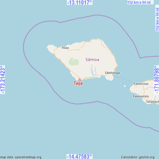
Taga GPS coordinates[2]
13° 47' 38.4" South, 172° 30' 39.96" West
| Map corner | latitude | longitude |
|---|---|---|
| Upper-left | -13.11017°, | -173.21423° |
| Center: | -13.794°, | -172.5111° |
| Lower-right: | -14.47583°, | -171.80798° |
| Map W x H: | 151.8×151.9 km | = 94.3×94.4mi |
| max Lat: | -13.44894° ⇑32.8% North |
| Taga: | -13.794° |
| min Lat: | ⇓67.2% South -14.04454° |
| min Long | Taga | max Long |
| -172.69436° | -172.5111° | -171.42559° |
| W 9.8%⇐ | ⇒90.2% E |
Elevation
Elevation of Taga is 16 m = 52 ft, and this is 7.9 m = 26 ft below average elevation for this country.
| Max E: |
252 m = 827 ft | 29.5% |
| Avg. | 23.9 m = 78 ft | |
| Taga | 16 m = 52 ft | |
Min E: |
7 m = 23 ft | 70.5% |
See also: Samoa elevation on elevation.city.
Geographical zone
Taga is located in South Torrid zone (between Equator and Tropic of Capricorn). Distance of this Southern Tropic circle is 1072.2 km =666.2 mi to South.| Distance of | km | miles | from Taga |
|---|---|---|---|
| Equator | 1533.7 | 953 | to North |
| Tropic Capricorn | 1072.2 | 666.2 | to South |
| Antarctic Circle | 5867.4 | 3645.8 | to South |
| South Pole | 8473.3 | 5265.1 | to South |


Nearby cities:
15 places around Taga: (largest is in red/bold)
• Asau
33.4 km =20.8 mi,  335°
335°
• Auala
34.4 km =21.4 mi,  333°
333°
• Gataivai
13.5 km =8.4 mi,  80°
80°
• Patamea
37.2 km =23.1 mi,  36°
36°
• Sagone
16.6 km =10.3 mi,  315°
315°
• Saipipi
38.5 km =23.9 mi,  61°
61°
• Sapapali’i
36.5 km =22.7 mi,  71°
71°
• Sasina
36.6 km =22.7 mi,  10°
10°
• Sataua
36.6 km =22.7 mi, 327°
• Satupa‘itea
20.1 km =12.5 mi, 81°
• Sa’asa’ai
38.4 km =23.9 mi, 63°
• Sili
15.1 km =9.4 mi, 73°
• Siutu
12.2 km =7.6 mi,  311°
311°
• Vailoa
22.5 km =14 mi, 79°
• Vaisala
35.8 km =22.2 mi, 330°
Sources, notices
• [Note1] Compared only with cities in Samoa existing in our database
• [Src1] Map data: © OpenStreetMap contributors (CC-BY-SA)
• [Src2] Other city data from geonames.org with taken over terms of usage.
• [Src3] Geographical zone / Annual Mean Temperature by Robert A. Rohde @ Wikipedia
