Sataua geodata
Sataua (Vaisigano) is a populated place; located in Samoa in Pacific/Apia (GMT+13) time zone. With population of 771 people, there are 32 cities with bigger population in this country. Compared to other cities in Samoa, 90.2% of cities are located further ↓South; 100% of cities are located further →East and 72.1% of cities have lower elevation than Sataua. Note1


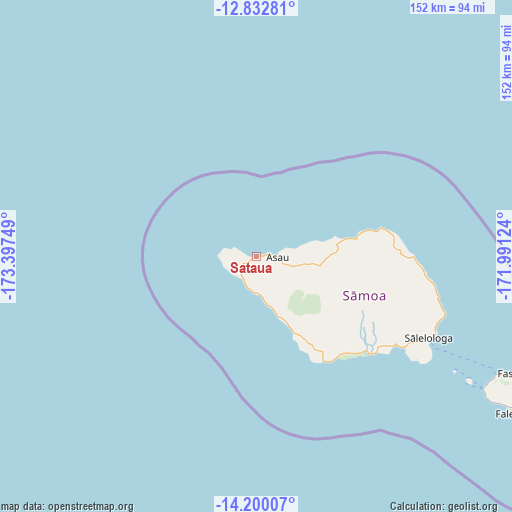
Sataua GPS coordinates[2]
13° 31' 2.712" South, 172° 41' 39.696" West
| Map corner | latitude | longitude |
|---|---|---|
| Upper-left | -12.83281°, | -173.39749° |
| Center: | -13.51742°, | -172.69436° |
| Lower-right: | -14.20007°, | -171.99124° |
| Map W x H: | 152×152 km | = 94.4×94.4mi |
| max Lat: | -13.44894° ⇑9.8% North |
| Sataua: | -13.51742° |
| min Lat: | ⇓90.2% South -14.04454° |
| min Long | Sataua | max Long |
| -172.69436° | -172.69436° | -171.42559° |
| W 0%⇐ | ⇒100% E |
Elevation
Elevation of Sataua is 17 m = 56 ft, and this is 6.9 m = 23 ft below average elevation for this country.
| Max E: |
252 m = 827 ft | 27.9% |
| Avg. | 23.9 m = 78 ft | |
| Sataua | 17 m = 56 ft | |
Min E: |
7 m = 23 ft | 72.1% |
See also: Samoa elevation on elevation.city.
Geographical zone
Sataua is located in South Torrid zone (between Equator and Tropic of Capricorn). Distance of this Southern Tropic circle is 1102.9 km =685.3 mi to South.| Distance of | km | miles | from Sataua |
|---|---|---|---|
| Equator | 1503 | 933.9 | to North |
| Tropic Capricorn | 1102.9 | 685.3 | to South |
| Antarctic Circle | 5898.2 | 3665 | to South |
| South Pole | 8504.1 | 5284.2 | to South |


Nearby cities:
15 places around Sataua: (largest is in red/bold)
• Asau
6.1 km =3.8 mi,  92°
92°
• Auala
4.5 km =2.8 mi, 88°
• Gataivai
43.7 km =27.2 mi,  130°
130°
• Patamea
41.9 km =26 mi, 91°
• Safotu
32.5 km =20.2 mi,  76°
76°
• Sagone
20.6 km =12.8 mi,  156°
156°
• Sale’aula
39.6 km =24.6 mi, 78°
• Samalaeulu
42.7 km =26.5 mi, 87°
• Sasina
27 km =16.8 mi, 78°
• Satupa‘itea
48.4 km =30.1 mi,  124°
124°
• Sili
43.3 km =26.9 mi, 127°
• Siutu
25 km =15.5 mi,  154°
154°
• Taga
36.6 km =22.7 mi, 147°
• Vailoa
49.5 km =30.8 mi, 122°
• Vaisala
2.1 km =1.3 mi, 80°
Sources, notices
• [Note1] Compared only with cities in Samoa existing in our database
• [Src1] Map data: © OpenStreetMap contributors (CC-BY-SA)
• [Src2] Other city data from geonames.org with taken over terms of usage.
• [Src3] Geographical zone / Annual Mean Temperature by Robert A. Rohde @ Wikipedia
