Sapapali’i geodata
Sapapali’i (Fa‘asaleleaga) is a populated place; located in Samoa in Pacific/Apia (GMT+13) time zone. With population of 877 people, there are 24 cities with bigger population in this country. Compared to other cities in Samoa, 78.7% of cities are located further ↓South; 68.9% of cities are located further →East and 78.7% of cities have higher elevation than Sapapali’i. Note1


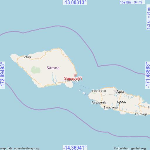
Sapapali’i GPS coordinates[2]
13° 41' 14.136" South, 172° 11' 30.48" West
| Map corner | latitude | longitude |
|---|---|---|
| Upper-left | -13.00313°, | -172.89493° |
| Center: | -13.68726°, | -172.1918° |
| Lower-right: | -14.36941°, | -171.48868° |
| Map W x H: | 151.9×151.9 km | = 94.4×94.4mi |
| max Lat: | -13.44894° ⇑21.3% North |
| Sapapali’i: | -13.68726° |
| min Lat: | ⇓78.7% South -14.04454° |
| min Long | Sapapali’i | max Long |
| -172.69436° | -172.1918° | -171.42559° |
| W 31.1%⇐ | ⇒68.9% E |
Elevation
Elevation of Sapapali’i is 10 m = 33 ft, and this is 13.9 m = 46 ft below average elevation for this country.
| Max E: |
252 m = 827 ft | 78.7% |
| Avg. | 23.9 m = 78 ft | |
| Sapapali’i | 10 m = 33 ft | |
Min E: |
7 m = 23 ft | 21.3% |
See also: Samoa elevation on elevation.city.
Geographical zone
Sapapali’i is located in South Torrid zone (between Equator and Tropic of Capricorn). Distance of this Southern Tropic circle is 1084 km =673.6 mi to South.| Distance of | km | miles | from Sapapali’i |
|---|---|---|---|
| Equator | 1521.9 | 945.7 | to North |
| Tropic Capricorn | 1084 | 673.6 | to South |
| Antarctic Circle | 5879.3 | 3653.2 | to South |
| South Pole | 8485.2 | 5272.5 | to South |


Nearby cities:
15 places around Sapapali’i: (largest is in red/bold)
• Faleatiu
27.9 km =17.3 mi,  124°
124°
• Gataivai
23.3 km =14.5 mi,  245°
245°
• Lano
7.8 km =4.8 mi,  354°
354°
• Leulumoega
29.1 km =18.1 mi, 121°
• Mulifanua
23.3 km =14.5 mi,  133°
133°
• Patamea
21.9 km =13.6 mi,  325°
325°
• Safotulafai
2.3 km =1.4 mi,  40°
40°
• Saipipi
6.5 km =4 mi, 354°
• Samalaeulu
23.8 km =14.8 mi, 330°
• Samatau
27.7 km =17.2 mi,  148°
148°
• Satapuala
28.2 km =17.5 mi, 125°
• Satupa‘itea
17 km =10.6 mi,  239°
239°
• Sa’asa’ai
5.6 km =3.5 mi,  357°
357°
• Sili
21.4 km =13.3 mi, 249°
• Vailoa
14.6 km =9.1 mi, 238°
Sources, notices
• [Note1] Compared only with cities in Samoa existing in our database
• [Src1] Map data: © OpenStreetMap contributors (CC-BY-SA)
• [Src2] Other city data from geonames.org with taken over terms of usage.
• [Src3] Geographical zone / Annual Mean Temperature by Robert A. Rohde @ Wikipedia
