Patamea geodata
Patamea (Gaga‘emauga) is a populated place; located in Samoa in Pacific/Apia (GMT+13) time zone. With population of 597 people, there are 46 cities with bigger population in this country. Compared to other cities in Samoa, 86.9% of cities are located further ↓South; 77% of cities are located further →East and 96.7% of cities have lower elevation than Patamea. Note1


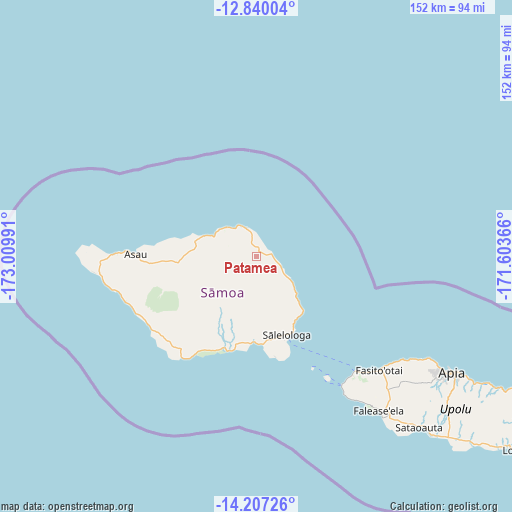
Patamea GPS coordinates[2]
13° 31' 28.668" South, 172° 18' 24.408" West
| Map corner | latitude | longitude |
|---|---|---|
| Upper-left | -12.84004°, | -173.00991° |
| Center: | -13.52463°, | -172.30678° |
| Lower-right: | -14.20726°, | -171.60366° |
| Map W x H: | 152×152 km | = 94.4×94.4mi |
| max Lat: | -13.44894° ⇑13.1% North |
| Patamea: | -13.52463° |
| min Lat: | ⇓86.9% South -14.04454° |
| min Long | Patamea | max Long |
| -172.69436° | -172.30678° | -171.42559° |
| W 23%⇐ | ⇒77% E |
Elevation
Elevation of Patamea is 97 m = 318 ft, and this is 73.1 m = 240 ft above average elevation for this country.
| Max E: |
252 m = 827 ft | 3.3% |
| Patamea | 97 m 318 ft | |
| Avg. | 23.9 m = 78 ft | |
Min E: |
7 m = 23 ft | 96.7% |
See also: Samoa elevation on elevation.city.
Geographical zone
Patamea is located in South Torrid zone (between Equator and Tropic of Capricorn). Distance of this Southern Tropic circle is 1102.1 km =684.8 mi to South.| Distance of | km | miles | from Patamea |
|---|---|---|---|
| Equator | 1503.8 | 934.4 | to North |
| Tropic Capricorn | 1102.1 | 684.8 | to South |
| Antarctic Circle | 5897.4 | 3664.5 | to South |
| South Pole | 8503.3 | 5283.7 | to South |


Nearby cities:
15 places around Patamea: (largest is in red/bold)
• Asau
35.8 km =22.2 mi,  270°
270°
• Gataivai
29 km =18 mi,  197°
197°
• Lano
15.6 km =9.7 mi,  131°
131°
• Safotu
13.1 km =8.1 mi,  308°
308°
• Safotulafai
21.5 km =13.4 mi,  139°
139°
• Saipipi
16.5 km =10.3 mi, 134°
• Sale’aula
9 km =5.6 mi,  339°
339°
• Samalaeulu
2.7 km =1.7 mi,  15°
15°
• Sapapali’i
21.9 km =13.6 mi,  145°
145°
• Sasina
16.6 km =10.3 mi,  291°
291°
• Satupa‘itea
26.9 km =16.7 mi,  184°
184°
• Sa’asa’ai
17.5 km =10.9 mi, 135°
• Sili
26.8 km =16.7 mi, 196°
• Taga
37.2 km =23.1 mi,  216°
216°
• Vailoa
25.7 km =16 mi, 180°
Sources, notices
• [Note1] Compared only with cities in Samoa existing in our database
• [Src1] Map data: © OpenStreetMap contributors (CC-BY-SA)
• [Src2] Other city data from geonames.org with taken over terms of usage.
• [Src3] Geographical zone / Annual Mean Temperature by Robert A. Rohde @ Wikipedia
