Qa‘ţabah geodata
Qa‘ţabah (Aḑ Ḑāli‘) is a seat of a second-order administrative division; located in Yemen in Asia/Aden (GMT+3) time zone. In our database, there are 51 cities with bigger population. Compared to other cities in Yemen, 80.5% of cities are located further ↑North; 58.1% of cities are located further ←West and 51.9% of cities have lower elevation than Qa‘ţabah. Note1


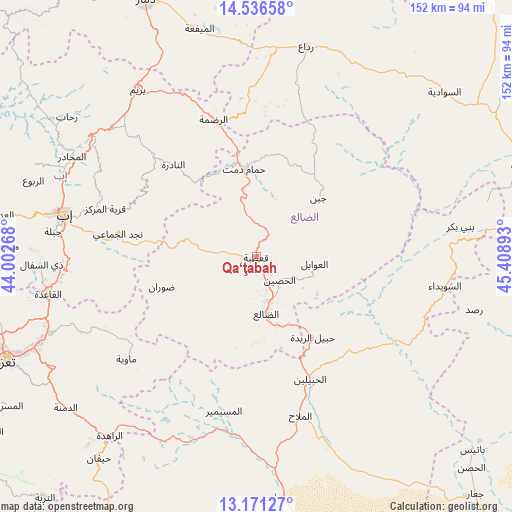
Qa‘ţabah GPS coordinates[2]
13° 51' 17.748" North, 44° 42' 20.88" East
| Map corner | latitude | longitude |
|---|---|---|
| Upper-left | 14.53658°, | 44.00268° |
| Center: | 13.85493°, | 44.7058° |
| Lower-right: | 13.17127°, | 45.40893° |
| Map W x H: | 151.8×151.8 km | = 94.3×94.3mi |
| max Lat: | 17.76999° ⇑80.5% North |
| Qa‘ţabah: | 13.85493° |
| min Lat: | ⇓19.5% South 12.18576° |
| min Long | Qa‘ţabah | max Long |
| 42.67107° | 44.7058° | 54.01895° |
| W 58.1%⇐ | ⇒41.9% E |
Elevation
Elevation of Qa‘ţabah is 1331 m = 4367 ft, and this is 26.2 m = 86 ft above average elevation for this country.
| Max E: |
2791 m = 9157 ft | 48.1% |
| Qa‘ţabah | 1331 m 4367 ft | |
| Avg. | 1304.8 m = 4281 ft | |
Min E: |
4 m = 13 ft | 51.9% |
See also: Yemen elevation on elevation.city.
Geographical zone
Qa‘ţabah is located in North Torrid zone (between Equator and Tropic of Cancer). Distance of this Northern Tropic circle is 1065.4 km =662 mi to North.| Distance of | km | miles | from Qa‘ţabah |
|---|---|---|---|
| North Pole | 8466.5 | 5260.8 | to North |
| Arctic Circle | 5860.7 | 3641.7 | to North |
| Tropic Cancer | 1065.4 | 662 | to North |
| Equator | 1540.5 | 957.2 | to South |


Nearby cities:
15 places around Qa‘ţabah: (largest is in red/bold)
• Al Madu
12.2 km =7.6 mi,  89°
89°
• Al Ḩabīlayn
40.4 km =25.1 mi,  157°
157°
• Al Ḩusayn
9.8 km =6.1 mi,  135°
135°
• Al ‘Awābil
17.2 km =10.7 mi,  96°
96°
• An Nādirah
36.6 km =22.7 mi,  317°
317°
• Ar Raḑmah
42.6 km =26.5 mi,  342°
342°
• Ar Riḑā’ī
38.2 km =23.7 mi,  298°
298°
• Dhalie
17.9 km =11.1 mi,  171°
171°
• Dhī Jalāl
25.7 km =16 mi,  179°
179°
• Juban
25.2 km =15.7 mi,  46°
46°
• Najd al Jamā‘ī
41.7 km =25.9 mi,  279°
279°
• Ḑawrān
29.9 km =18.6 mi,  252°
252°
• Ḩabīl al Jabr
41.1 km =25.5 mi,  132°
132°
• Ḩabīl ar Raydah
28.2 km =17.5 mi,  146°
146°
• Ḩammām Damt
26.5 km =16.5 mi,  351°
351°
Sources, notices
• [Note1] Compared only with cities in Yemen existing in our database
• [Src1] Map data: © OpenStreetMap contributors (CC-BY-SA)
• [Src2] Other city data from geonames.org with taken over terms of usage.
• [Src3] Geographical zone / Annual Mean Temperature by Robert A. Rohde @ Wikipedia
