Dhī Jalāl geodata
Dhī Jalāl (Aḑ Ḑāli‘) is a seat of a second-order administrative division; located in Yemen in Asia/Aden (GMT+3) time zone. In our database, there are 51 cities with bigger population. Compared to other cities in Yemen, 87.3% of cities are located further ↑North; 58.4% of cities are located further ←West and 54.9% of cities have higher elevation than Dhī Jalāl. Note1


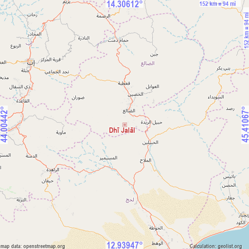
Dhī Jalāl GPS coordinates[2]
13° 37' 25.608" North, 44° 42' 27.144" East
| Map corner | latitude | longitude |
|---|---|---|
| Upper-left | 14.30612°, | 44.00442° |
| Center: | 13.62378°, | 44.70754° |
| Lower-right: | 12.93947°, | 45.41067° |
| Map W x H: | 152×152 km | = 94.4×94.4mi |
| max Lat: | 17.76999° ⇑87.3% North |
| Dhī Jalāl: | 13.62378° |
| min Lat: | ⇓12.7% South 12.18576° |
| min Long | Dhī Jalāl | max Long |
| 42.67107° | 44.70754° | 54.01895° |
| W 58.4%⇐ | ⇒41.6% E |
Elevation
Elevation of Dhī Jalāl is 1219 m = 3999 ft, and this is 85.8 m = 281 ft below average elevation for this country.
| Max E: |
2791 m = 9157 ft | 54.9% |
| Avg. | 1304.8 m = 4281 ft | |
| Dhī Jalāl | 1219 m = 3999 ft | |
Min E: |
4 m = 13 ft | 45.1% |
See also: Yemen elevation on elevation.city.
Geographical zone
Dhī Jalāl is located in North Torrid zone (between Equator and Tropic of Cancer). Distance of this Northern Tropic circle is 1091.1 km =678 mi to North.| Distance of | km | miles | from Dhī Jalāl |
|---|---|---|---|
| North Pole | 8492.2 | 5276.8 | to North |
| Arctic Circle | 5886.4 | 3657.6 | to North |
| Tropic Cancer | 1091.1 | 678 | to North |
| Equator | 1514.8 | 941.3 | to South |


Nearby cities:
15 places around Dhī Jalāl: (largest is in red/bold)
• Al Madu
28.5 km =17.7 mi,  24°
24°
• Al Milāḩ
25.4 km =15.8 mi,  149°
149°
• Al Musaymīr
22.4 km =13.9 mi,  206°
206°
• Al Ḩabīlayn
19.3 km =12 mi,  126°
126°
• Al Ḩusayn
19.8 km =12.3 mi, 19°
• Al ‘Awābil
29.2 km =18.1 mi,  35°
35°
• Dhalie
8.4 km =5.2 mi, 17°
• Juban
46.7 km =29 mi, 22°
• Kirsh
37.2 km =23.1 mi,  219°
219°
• Māwiyah
39.2 km =24.4 mi,  263°
263°
• Qa‘ţabah
25.7 km =16 mi,  359°
359°
• Ḑawrān
33.2 km =20.6 mi,  300°
300°
• Ḩabīl al Jabr
30.1 km =18.7 mi,  94°
94°
• Ḩabīl ar Raydah
15.7 km =9.8 mi,  81°
81°
• Ḩammām Damt
52 km =32.3 mi, 355°
Sources, notices
• [Note1] Compared only with cities in Yemen existing in our database
• [Src1] Map data: © OpenStreetMap contributors (CC-BY-SA)
• [Src2] Other city data from geonames.org with taken over terms of usage.
• [Src3] Geographical zone / Annual Mean Temperature by Robert A. Rohde @ Wikipedia
