Z̧almah al ‘Ulyā geodata
Z̧almah al ‘Ulyā (Ibb) is a seat of a second-order administrative division; located in Yemen in Asia/Aden (GMT+3) time zone. In our database, there are 51 cities with bigger population. Compared to other cities in Yemen, 72.1% of cities are located further ↑North; 61.7% of cities are located further →East and 81.5% of cities have lower elevation than Z̧almah al ‘Ulyā. Note1


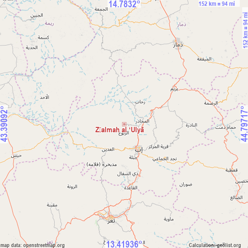
Z̧almah al ‘Ulyā GPS coordinates[2]
14° 6' 8.28" North, 44° 5' 38.544" East
| Map corner | latitude | longitude |
|---|---|---|
| Upper-left | 14.7832°, | 43.39092° |
| Center: | 14.1023°, | 44.09404° |
| Lower-right: | 13.41936°, | 44.79717° |
| Map W x H: | 151.6×151.6 km | = 94.2×94.2mi |
| max Lat: | 17.76999° ⇑72.1% North |
| Z̧almah al ‘Ulyā: | 14.1023° |
| min Lat: | ⇓27.9% South 12.18576° |
| min Long | Z̧almah al ‘ | max Long |
| 42.67107° | 44.09404° | 54.01895° |
| W 38.3%⇐ | ⇒61.7% E |
Elevation
Elevation of Z̧almah al ‘Ulyā is 2145 m = 7037 ft, and this is 840.2 m = 2757 ft above average elevation for this country.
| Max E: |
2791 m = 9157 ft | 18.5% |
| Z̧almah al ‘Ulyā | 2145 m 7037 ft | |
| Avg. | 1304.8 m = 4281 ft | |
Min E: |
4 m = 13 ft | 81.5% |
See also: Yemen elevation on elevation.city.
Geographical zone
Z̧almah al ‘Ulyā is located in North Torrid zone (between Equator and Tropic of Cancer). Distance of this Northern Tropic circle is 1037.9 km =644.9 mi to North.| Distance of | km | miles | from Z̧almah al ‘Ulyā |
|---|---|---|---|
| North Pole | 8439 | 5243.7 | to North |
| Arctic Circle | 5833.1 | 3624.5 | to North |
| Tropic Cancer | 1037.9 | 644.9 | to North |
| Equator | 1568 | 974.3 | to South |


Nearby cities:
15 places around Z̧almah al ‘Ulyā: (largest is in red/bold)
• Al Makhādir
11.4 km =7.1 mi,  78°
78°
• Al ‘Udayn
18.1 km =11.2 mi,  215°
215°
• Ar Ramādī
37.1 km =23.1 mi,  244°
244°
• Ar Riḑā’ī
33.7 km =20.9 mi,  106°
106°
• As Saddah
35.4 km =22 mi,  86°
86°
• As Sayyānī
30.1 km =18.7 mi,  163°
163°
• Dhī as Sufāl
29.9 km =18.6 mi,  175°
175°
• Ibb
17.9 km =11.1 mi,  147°
147°
• Jiblah
20.9 km =13 mi, 164°
• Markaz Mudhaykirah
27.2 km =16.9 mi,  209°
209°
• Najd al Jamā‘ī
32.4 km =20.1 mi,  129°
129°
• Qaryat ad Da‘īs
23.3 km =14.5 mi,  123°
123°
• Riḩāb
17.2 km =10.7 mi,  36°
36°
• Yarīm
37.6 km =23.4 mi,  54°
54°
• Ḩazm al ‘Udayn
12.7 km =7.9 mi,  228°
228°
Sources, notices
• [Note1] Compared only with cities in Yemen existing in our database
• [Src1] Map data: © OpenStreetMap contributors (CC-BY-SA)
• [Src2] Other city data from geonames.org with taken over terms of usage.
• [Src3] Geographical zone / Annual Mean Temperature by Robert A. Rohde @ Wikipedia
