Yarīm geodata
Yarīm (Ibb) is a seat of a second-order administrative division; located in Yemen in Asia/Aden (GMT+3) time zone. With population of 33,050 people, there are 17 cities with bigger population in this country. Compared to other cities in Yemen, 66.9% of cities are located further ↑North; 50.3% of cities are located further ←West and 98.4% of cities have lower elevation than Yarīm. Note1


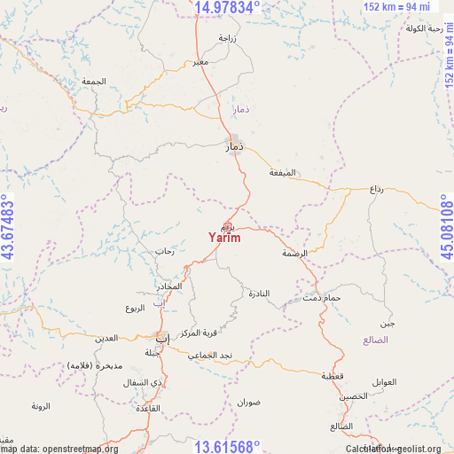
Yarīm GPS coordinates[2]
14° 17' 52.944" North, 44° 22' 40.62" East
| Map corner | latitude | longitude |
|---|---|---|
| Upper-left | 14.97834°, | 43.67483° |
| Center: | 14.29804°, | 44.37795° |
| Lower-right: | 13.61568°, | 45.08108° |
| Map W x H: | 151.5×151.5 km | = 94.1×94.1mi |
| max Lat: | 17.76999° ⇑66.9% North |
| Yarīm: | 14.29804° |
| min Lat: | ⇓33.1% South 12.18576° |
| min Long | Yarīm | max Long |
| 42.67107° | 44.37795° | 54.01895° |
| W 50.3%⇐ | ⇒49.7% E |
Elevation
Elevation of Yarīm is 2626 m = 8615 ft, and this is 1321.2 m = 4335 ft above average elevation for this country.
| Max E: |
2791 m = 9157 ft | 1.6% |
| Yarīm | 2626 m 8615 ft | |
| Avg. | 1304.8 m = 4281 ft | |
Min E: |
4 m = 13 ft | 98.4% |
See also: Yemen elevation on elevation.city.
Geographical zone
Yarīm is located in North Torrid zone (between Equator and Tropic of Cancer). Distance of this Northern Tropic circle is 1016.1 km =631.4 mi to North.| Distance of | km | miles | from Yarīm |
|---|---|---|---|
| North Pole | 8417.3 | 5230.3 | to North |
| Arctic Circle | 5811.4 | 3611 | to North |
| Tropic Cancer | 1016.1 | 631.4 | to North |
| Equator | 1589.8 | 987.9 | to South |


Nearby cities:
15 places around Yarīm: (largest is in red/bold)
• Al Makhādir
27.5 km =17.1 mi,  224°
224°
• Al Mayfa’ah
26 km =16.2 mi,  44°
44°
• An Nādirah
24.8 km =15.4 mi,  154°
154°
• Ar Raḑmah
24.1 km =15 mi,  111°
111°
• Ar Riḑā’ī
31.3 km =19.4 mi,  176°
176°
• As Saddah
20.1 km =12.5 mi,  166°
166°
• Dhamār
27.4 km =17 mi,  6°
6°
• Ibb
42.4 km =26.3 mi,  209°
209°
• Najd al Jamā‘ī
42.9 km =26.7 mi,  187°
187°
• Qaryat ad Da‘īs
36.3 km =22.6 mi,  197°
197°
• Riḩāb
21.9 km =13.6 mi,  249°
249°
• Zakhim
33.1 km =20.6 mi,  90°
90°
• Z̧almah al ‘Ulyā
37.6 km =23.4 mi,  234°
234°
• Ḑubāh
34.1 km =21.2 mi,  308°
308°
• Ḩammām Damt
39.1 km =24.3 mi,  126°
126°
Sources, notices
• [Note1] Compared only with cities in Yemen existing in our database
• [Src1] Map data: © OpenStreetMap contributors (CC-BY-SA)
• [Src2] Other city data from geonames.org with taken over terms of usage.
• [Src3] Geographical zone / Annual Mean Temperature by Robert A. Rohde @ Wikipedia
