Grabouw geodata
Grabouw (Western Cape) is a populated place; located in South Africa in Africa/Johannesburg (GMT+2) time zone. With population of 29,885 people, there are 124 cities with bigger population in this country. Compared to other cities in South Africa, 98.2% of cities are located further ↑North; 92.6% of cities are located further →East and 79.1% of cities have higher elevation than Grabouw. Note1
Administrative division(s):
- Level 1: Western Cape
- Level 2: Overberg District Municipality
- Level 3: Theewaterskloof


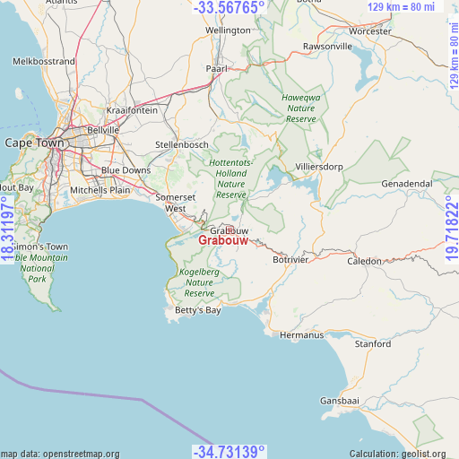
Grabouw GPS coordinates[2]
34° 9' 5.472" South, 19° 0' 54.324" East
| Map corner | latitude | longitude |
|---|---|---|
| Upper-left | -33.56765°, | 18.31197° |
| Center: | -34.15152°, | 19.01509° |
| Lower-right: | -34.73139°, | 19.71822° |
| Map W x H: | 129.4×129.4 km | = 80.4×80.4mi |
| max Lat: | -22.34881° ⇑98.2% North |
| Grabouw: | -34.15152° |
| min Lat: | ⇓1.8% South -34.66739° |
| min Long | Grabouw | max Long |
| 16.8697° | 19.01509° | 32.26762° |
| W 7.4%⇐ | ⇒92.6% E |
Elevation
Elevation of Grabouw is 332 m = 1089 ft, and this is 637.6 m = 2092 ft below average elevation for this country.
| Max E: |
1873 m = 6145 ft | 79.1% |
| Avg. | 969.6 m = 3181 ft | |
| Grabouw | 332 m = 1089 ft | |
Min E: |
7 m = 23 ft | 20.9% |
See also: South Africa elevation on elevation.city.
Geographical zone
Grabouw is located in South temperate zone (between Tropic of Capricorn and the Antarctic Circle). Distance of this Southern Tropic circle is 1191.4 km =740.3 mi to North.| Distance of | km | miles | from Grabouw |
|---|---|---|---|
| Equator | 3797.3 | 2359.5 | to North |
| Tropic Capricorn | 1191.4 | 740.3 | to North |
| Antarctic Circle | 3603.9 | 2239.4 | to South |
| South Pole | 6209.8 | 3858.6 | to South |


Nearby cities:
15 places around Grabouw: (largest is in red/bold)
• Bergvliet
53.1 km =33 mi,  282°
282°
• Caledon
38.8 km =24.1 mi,  102°
102°
• Claremont
54.1 km =33.6 mi,  290°
290°
• Constantia
56.6 km =35.2 mi, 283°
• Hermanus
35.9 km =22.3 mi,  145°
145°
• Kraaifontein
43.5 km =27 mi,  320°
320°
• Lansdowne
51.1 km =31.8 mi, 290°
• Newlands
55.7 km =34.6 mi, 290°
• Paarl
46.6 km =29 mi,  355°
355°
• Retreat
50.8 km =31.6 mi, 282°
• Rondebosch
53.9 km =33.5 mi, 292°
• Rosebank
54.4 km =33.8 mi, 293°
• Stellenbosch
27.7 km =17.2 mi,  330°
330°
• Sunset Beach
58.5 km =36.4 mi,  304°
304°
• Wellington
56.9 km =35.4 mi, 359°
Sources, notices
• [Note1] Compared only with cities in South Africa existing in our database
• [Src1] Map data: © OpenStreetMap contributors (CC-BY-SA)
• [Src2] Other city data from geonames.org with taken over terms of usage.
• [Src3] Geographical zone / Annual Mean Temperature by Robert A. Rohde @ Wikipedia
