Retreat geodata
Retreat (Western Cape) is a populated place; located in South Africa in Africa/Johannesburg (GMT+2) time zone. With population of 32,289 people, there are 120 cities with bigger population in this country. Compared to other cities in South Africa, 97.6% of cities are located further ↑North; 96.8% of cities are located further →East and 99.4% of cities have higher elevation than Retreat. Note1
Administrative division(s):
- Level 1: Western Cape
- Level 2: City of Cape Town
- Level 3: City of Cape Town


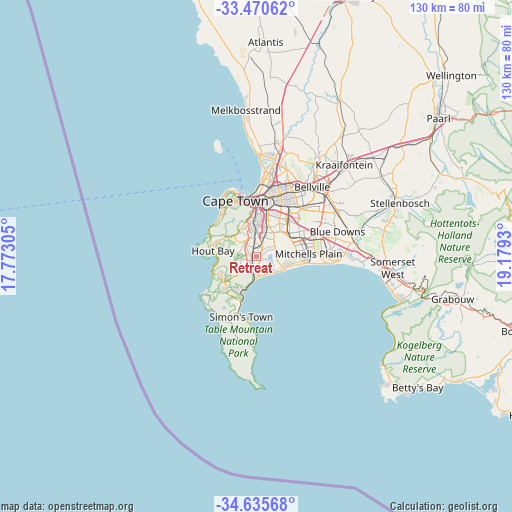
Retreat GPS coordinates[2]
34° 3' 18.54" South, 18° 28' 34.212" East
| Map corner | latitude | longitude |
|---|---|---|
| Upper-left | -33.47062°, | 17.77305° |
| Center: | -34.05515°, | 18.47617° |
| Lower-right: | -34.63568°, | 19.1793° |
| Map W x H: | 129.5×129.5 km | = 80.5×80.5mi |
| max Lat: | -22.34881° ⇑97.6% North |
| Retreat: | -34.05515° |
| min Lat: | ⇓2.4% South -34.66739° |
| min Long | Retreat | max Long |
| 16.8697° | 18.47617° | 32.26762° |
| W 3.2%⇐ | ⇒96.8% E |
Elevation
Elevation of Retreat is 8 m = 26 ft, and this is 961.6 m = 3155 ft below average elevation for this country.
| Max E: |
1873 m = 6145 ft | 99.4% |
| Avg. | 969.6 m = 3181 ft | |
| Retreat | 8 m = 26 ft | |
Min E: |
7 m = 23 ft | 0.6% |
See also: South Africa elevation on elevation.city.
Geographical zone
Retreat is located in South temperate zone (between Tropic of Capricorn and the Antarctic Circle). Distance of this Southern Tropic circle is 1180.7 km =733.7 mi to North.| Distance of | km | miles | from Retreat |
|---|---|---|---|
| Equator | 3786.6 | 2352.9 | to North |
| Tropic Capricorn | 1180.7 | 733.7 | to North |
| Antarctic Circle | 3614.6 | 2246 | to South |
| South Pole | 6220.5 | 3865.2 | to South |


Nearby cities:
15 places around Retreat: (largest is in red/bold)
• Atlantis
54.3 km =33.7 mi,  0°
0°
• Bergvliet
2.3 km =1.4 mi,  291°
291°
• Cape Town
15.2 km =9.4 mi,  341°
341°
• Claremont
8.4 km =5.2 mi,  353°
353°
• Constantia
5.9 km =3.7 mi,  296°
296°
• Grabouw
50.8 km =31.6 mi,  102°
102°
• Kraaifontein
32 km =19.9 mi,  43°
43°
• Lansdowne
7.8 km =4.8 mi,  14°
14°
• Newlands
8.9 km =5.5 mi, 343°
• Paarl
58.3 km =36.2 mi,  52°
52°
• Rondebosch
10.2 km =6.3 mi, 0°
• Rosebank
11.1 km =6.9 mi,  359°
359°
• Stellenbosch
38.4 km =23.9 mi,  69°
69°
• Sunset Beach
22.4 km =13.9 mi, 3°
• Wellington
67.6 km =42 mi, 46°
Sources, notices
• [Note1] Compared only with cities in South Africa existing in our database
• [Src1] Map data: © OpenStreetMap contributors (CC-BY-SA)
• [Src2] Other city data from geonames.org with taken over terms of usage.
• [Src3] Geographical zone / Annual Mean Temperature by Robert A. Rohde @ Wikipedia
