Ceres geodata
Ceres (Western Cape) is a seat of a third-order administrative division; located in South Africa in Africa/Johannesburg (GMT+2) time zone. With population of 41,596 people, there are 103 cities with bigger population in this country. Compared to other cities in South Africa, 87% of cities are located further ↑North; 92% of cities are located further →East and 77.3% of cities have higher elevation than Ceres. Note1
Administrative division(s):
- Level 1: Western Cape
- Level 2: Cape Winelands District Municipality
- Level 3: Witzenberg


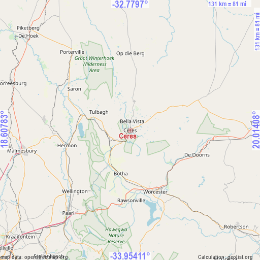
Ceres GPS coordinates[2]
33° 22' 8.004" South, 19° 18' 39.42" East
| Map corner | latitude | longitude |
|---|---|---|
| Upper-left | -32.7797°, | 18.60783° |
| Center: | -33.36889°, | 19.31095° |
| Lower-right: | -33.95411°, | 20.01408° |
| Map W x H: | 130.6×130.6 km | = 81.2×81.2mi |
| max Lat: | -22.34881° ⇑87% North |
| Ceres: | -33.36889° |
| min Lat: | ⇓13% South -34.66739° |
| min Long | Ceres | max Long |
| 16.8697° | 19.31095° | 32.26762° |
| W 8%⇐ | ⇒92% E |
Elevation
Elevation of Ceres is 457 m = 1499 ft, and this is 512.6 m = 1682 ft below average elevation for this country.
| Max E: |
1873 m = 6145 ft | 77.3% |
| Avg. | 969.6 m = 3181 ft | |
| Ceres | 457 m = 1499 ft | |
Min E: |
7 m = 23 ft | 22.7% |
See also: Ceres elevation on elevation.city.
Geographical zone
Ceres is located in South temperate zone (between Tropic of Capricorn and the Antarctic Circle). Distance of this Southern Tropic circle is 1104.4 km =686.2 mi to North.| Distance of | km | miles | from Ceres |
|---|---|---|---|
| Equator | 3710.3 | 2305.5 | to North |
| Tropic Capricorn | 1104.4 | 686.2 | to North |
| Antarctic Circle | 3690.9 | 2293.4 | to South |
| South Pole | 6296.8 | 3912.6 | to South |


Nearby cities:
15 places around Ceres: (largest is in red/bold)
• Ashton
86 km =53.4 mi,  126°
126°
• Atlantis
79.9 km =49.6 mi,  254°
254°
• Caledon
96.3 km =59.8 mi,  173°
173°
• Grabouw
91.2 km =56.7 mi,  197°
197°
• Kraaifontein
76.6 km =47.6 mi,  225°
225°
• Malmesbury
55.1 km =34.2 mi,  259°
259°
• Montagu
88.3 km =54.9 mi,  121°
121°
• Moorreesburg
65 km =40.4 mi,  291°
291°
• Paarl
51.1 km =31.8 mi,  217°
217°
• Piketberg
73.1 km =45.4 mi,  315°
315°
• Robertson
71.9 km =44.7 mi, 132°
• Stellenbosch
75.1 km =46.7 mi,  213°
213°
• Sunset Beach
93 km =57.8 mi, 234°
• Wellington
41 km =25.5 mi, 222°
• Worcester
33.4 km =20.8 mi,  157°
157°
Sources, notices
• [Note1] Compared only with cities in South Africa existing in our database
• [Src1] Map data: © OpenStreetMap contributors (CC-BY-SA)
• [Src2] Other city data from geonames.org with taken over terms of usage.
• [Src3] Geographical zone / Annual Mean Temperature by Robert A. Rohde @ Wikipedia
