Caledon geodata
Caledon (Western Cape) is a seat of a third-order administrative division; located in South Africa in Africa/Johannesburg (GMT+2) time zone. With population of 4,687 people, there are 237 cities with bigger population in this country. Compared to other cities in South Africa, 99.1% of cities are located further ↑North; 91.4% of cities are located further →East and 80.8% of cities have higher elevation than Caledon. Note1
Administrative division(s):
- Level 1: Western Cape
- Level 2: Overberg District Municipality
- Level 3: Theewaterskloof


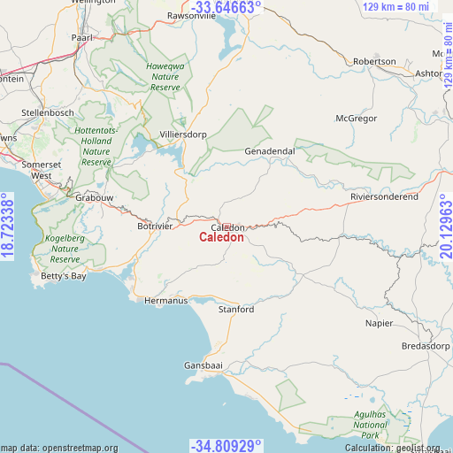
Caledon GPS coordinates[2]
34° 13' 47.892" South, 19° 25' 35.4" East
| Map corner | latitude | longitude |
|---|---|---|
| Upper-left | -33.64663°, | 18.72338° |
| Center: | -34.22997°, | 19.4265° |
| Lower-right: | -34.80929°, | 20.12963° |
| Map W x H: | 129.3×129.3 km | = 80.3×80.3mi |
| max Lat: | -22.34881° ⇑99.1% North |
| Caledon: | -34.22997° |
| min Lat: | ⇓0.9% South -34.66739° |
| min Long | Caledon | max Long |
| 16.8697° | 19.4265° | 32.26762° |
| W 8.6%⇐ | ⇒91.4% E |
Elevation
Elevation of Caledon is 260 m = 853 ft, and this is 709.6 m = 2328 ft below average elevation for this country.
| Max E: |
1873 m = 6145 ft | 80.8% |
| Avg. | 969.6 m = 3181 ft | |
| Caledon | 260 m = 853 ft | |
Min E: |
7 m = 23 ft | 19.2% |
See also: South Africa elevation on elevation.city.
Geographical zone
Caledon is located in South temperate zone (between Tropic of Capricorn and the Antarctic Circle). Distance of this Southern Tropic circle is 1200.1 km =745.7 mi to North.| Distance of | km | miles | from Caledon |
|---|---|---|---|
| Equator | 3806 | 2364.9 | to North |
| Tropic Capricorn | 1200.1 | 745.7 | to North |
| Antarctic Circle | 3595.2 | 2234 | to South |
| South Pole | 6201 | 3853.1 | to South |


Nearby cities:
15 places around Caledon: (largest is in red/bold)
• Arniston
88.3 km =54.9 mi,  123°
123°
• Ashton
73 km =45.4 mi,  52°
52°
• Bergvliet
91.9 km =57.1 mi,  282°
282°
• Bredasdorp
65.6 km =40.8 mi, 120°
• Grabouw
38.8 km =24.1 mi, 282°
• Hermanus
27.4 km =17 mi,  220°
220°
• Kraaifontein
77.9 km =48.4 mi,  303°
303°
• Lansdowne
89.7 km =55.7 mi,  287°
287°
• Montagu
80.8 km =50.2 mi, 52°
• Paarl
69.1 km =42.9 mi,  322°
322°
• Retreat
89.6 km =55.7 mi, 282°
• Robertson
63.5 km =39.5 mi,  41°
41°
• Stellenbosch
61.1 km =38 mi, 302°
• Wellington
76 km =47.2 mi,  329°
329°
• Worcester
64.9 km =40.3 mi,  1°
1°
Sources, notices
• [Note1] Compared only with cities in South Africa existing in our database
• [Src1] Map data: © OpenStreetMap contributors (CC-BY-SA)
• [Src2] Other city data from geonames.org with taken over terms of usage.
• [Src3] Geographical zone / Annual Mean Temperature by Robert A. Rohde @ Wikipedia
