Mkuze geodata
Mkuze (KwaZulu-Natal) is a seat of a second-order administrative division; located in South Africa in Africa/Johannesburg (GMT+2) time zone. In our database, there are 257 cities with bigger population. Compared to other cities in South Africa, 62.8% of cities are located further ↓South; 98.8% of cities are located further ←West and 86.1% of cities have higher elevation than Mkuze. Note1
Administrative division(s):
- Level 1: KwaZulu-Natal
- Level 2: uMkhanyakude District Municipality
- Level 3: Jozini


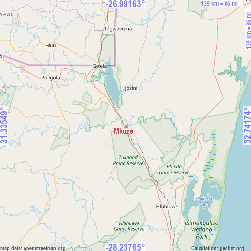
Mkuze GPS coordinates[2]
27° 36' 59.076" South, 32° 2' 18.996" East
| Map corner | latitude | longitude |
|---|---|---|
| Upper-left | -26.99163°, | 31.33549° |
| Center: | -27.61641°, | 32.03861° |
| Lower-right: | -28.23765°, | 32.74174° |
| Map W x H: | 138.5×138.5 km | = 86.1×86.1mi |
| max Lat: | -22.34881° ⇑37.2% North |
| Mkuze: | -27.61641° |
| min Lat: | ⇓62.8% South -34.66739° |
| min Long | Mkuze | max Long |
| 16.8697° | 32.03861° | 32.26762° |
| W 98.8%⇐ | ⇒1.2% E |
Elevation
Elevation of Mkuze is 126 m = 413 ft, and this is 843.6 m = 2768 ft below average elevation for this country.
| Max E: |
1873 m = 6145 ft | 86.1% |
| Avg. | 969.6 m = 3181 ft | |
| Mkuze | 126 m = 413 ft | |
Min E: |
7 m = 23 ft | 13.9% |
See also: South Africa elevation on elevation.city.
Geographical zone
Mkuze is located in South temperate zone (between Tropic of Capricorn and the Antarctic Circle). Distance of this Southern Tropic circle is 464.7 km =288.8 mi to North.| Distance of | km | miles | from Mkuze |
|---|---|---|---|
| Equator | 3070.7 | 1908 | to North |
| Tropic Capricorn | 464.7 | 288.8 | to North |
| Antarctic Circle | 4330.5 | 2690.8 | to South |
| South Pole | 6936.4 | 4310.1 | to South |


Nearby cities:
15 places around Mkuze: (largest is in red/bold)
• Empangeni
128.2 km =79.7 mi,  186°
186°
• Hlabisa
60.9 km =37.8 mi,  195°
195°
• Hluhluwe
50.1 km =31.1 mi,  153°
153°
• Jozini
21 km =13 mi,  7°
7°
• KwaMbonambi
109.3 km =67.9 mi,  177°
177°
• Melmoth
124.9 km =77.6 mi,  210°
210°
• Mondlo
136.2 km =84.6 mi,  252°
252°
• Mtubatuba
90.3 km =56.1 mi,  170°
170°
• Nongoma
50.4 km =31.3 mi,  229°
229°
• Paulpietersburg
122.4 km =76.1 mi,  280°
280°
• Piet Retief
138.7 km =86.2 mi,  299°
299°
• Pongola
49.1 km =30.5 mi, 302°
• Richards Bay
129.7 km =80.6 mi, 180°
• Ulundi
100.6 km =62.5 mi,  217°
217°
• Vryheid
123.9 km =77 mi,  262°
262°
Sources, notices
• [Note1] Compared only with cities in South Africa existing in our database
• [Src1] Map data: © OpenStreetMap contributors (CC-BY-SA)
• [Src2] Other city data from geonames.org with taken over terms of usage.
• [Src3] Geographical zone / Annual Mean Temperature by Robert A. Rohde @ Wikipedia
