Libode geodata
Libode (Eastern Cape) is a seat of a third-order administrative division; located in South Africa in Africa/Johannesburg (GMT+2) time zone. In our database, there are 257 cities with bigger population. Compared to other cities in South Africa, 76.7% of cities are located further ↑North; 69% of cities are located further ←West and 66.4% of cities have higher elevation than Libode. Note1
Administrative division(s):
- Level 1: Eastern Cape
- Level 2: OR Tambo District Municipality
- Level 3: Nyandeni


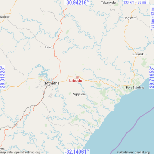
Libode GPS coordinates[2]
31° 32' 35.916" South, 29° 0' 59.04" East
| Map corner | latitude | longitude |
|---|---|---|
| Upper-left | -30.94216°, | 28.31328° |
| Center: | -31.54331°, | 29.0164° |
| Lower-right: | -32.14061°, | 29.71953° |
| Map W x H: | 133.3×133.3 km | = 82.8×82.8mi |
| max Lat: | -22.34881° ⇑76.7% North |
| Libode: | -31.54331° |
| min Lat: | ⇓23.3% South -34.66739° |
| min Long | Libode | max Long |
| 16.8697° | 29.0164° | 32.26762° |
| W 69%⇐ | ⇒31% E |
Elevation
Elevation of Libode is 792 m = 2598 ft, and this is 177.6 m = 583 ft below average elevation for this country.
| Max E: |
1873 m = 6145 ft | 66.4% |
| Avg. | 969.6 m = 3181 ft | |
| Libode | 792 m = 2598 ft | |
Min E: |
7 m = 23 ft | 33.6% |
See also: South Africa elevation on elevation.city.
Geographical zone
Libode is located in South temperate zone (between Tropic of Capricorn and the Antarctic Circle). Distance of this Southern Tropic circle is 901.4 km =560.1 mi to North.| Distance of | km | miles | from Libode |
|---|---|---|---|
| Equator | 3507.3 | 2179.3 | to North |
| Tropic Capricorn | 901.4 | 560.1 | to North |
| Antarctic Circle | 3893.9 | 2419.6 | to South |
| South Pole | 6499.8 | 4038.8 | to South |


Nearby cities:
15 places around Libode: (largest is in red/bold)
• Bizana
110.1 km =68.4 mi,  46°
46°
• Butterworth
119.8 km =74.4 mi,  223°
223°
• Cala
125.2 km =77.8 mi,  271°
271°
• Elliot
113.1 km =70.3 mi,  281°
281°
• Flagstaff
68.7 km =42.7 mi,  41°
41°
• Harding
135.6 km =84.3 mi, 37°
• Izingolweni
134.9 km =83.8 mi, 51°
• Kokstad
117.4 km =72.9 mi,  19°
19°
• Maclear
82.1 km =51 mi,  309°
309°
• Matatiele
134.8 km =83.8 mi,  351°
351°
• Mount Ayliff
88.3 km =54.9 mi, 22°
• Mount Frere
71.4 km =44.4 mi,  358°
358°
• Mthatha
22.6 km =14 mi,  257°
257°
• Port Saint John’s
50.8 km =31.6 mi,  100°
100°
• Qumbu
44.5 km =27.7 mi,  341°
341°
Sources, notices
• [Note1] Compared only with cities in South Africa existing in our database
• [Src1] Map data: © OpenStreetMap contributors (CC-BY-SA)
• [Src2] Other city data from geonames.org with taken over terms of usage.
• [Src3] Geographical zone / Annual Mean Temperature by Robert A. Rohde @ Wikipedia
