Maclear geodata
Maclear (Eastern Cape) is a seat of a third-order administrative division; located in South Africa in Africa/Johannesburg (GMT+2) time zone. In our database, there are 257 cities with bigger population. Compared to other cities in South Africa, 73.2% of cities are located further ↑North; 63.1% of cities are located further ←West and 61.4% of cities have lower elevation than Maclear. Note1
Administrative division(s):
- Level 1: Eastern Cape
- Level 2: Joe Gqabi District Municipality
- Level 3: Elundini


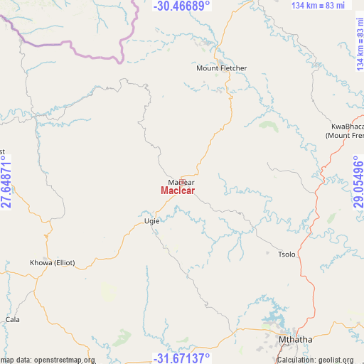
Maclear GPS coordinates[2]
31° 4' 15.744" South, 28° 21' 6.588" East
| Map corner | latitude | longitude |
|---|---|---|
| Upper-left | -30.46689°, | 27.64871° |
| Center: | -31.07104°, | 28.35183° |
| Lower-right: | -31.67137°, | 29.05496° |
| Map W x H: | 133.9×133.9 km | = 83.2×83.2mi |
| max Lat: | -22.34881° ⇑73.2% North |
| Maclear: | -31.07104° |
| min Lat: | ⇓26.8% South -34.66739° |
| min Long | Maclear | max Long |
| 16.8697° | 28.35183° | 32.26762° |
| W 63.1%⇐ | ⇒36.9% E |
Elevation
Elevation of Maclear is 1262 m = 4140 ft, and this is 292.4 m = 959 ft above average elevation for this country.
| Max E: |
1873 m = 6145 ft | 38.6% |
| Maclear | 1262 m 4140 ft | |
| Avg. | 969.6 m = 3181 ft | |
Min E: |
7 m = 23 ft | 61.4% |
See also: South Africa elevation on elevation.city.
Geographical zone
Maclear is located in South temperate zone (between Tropic of Capricorn and the Antarctic Circle). Distance of this Southern Tropic circle is 848.9 km =527.5 mi to North.| Distance of | km | miles | from Maclear |
|---|---|---|---|
| Equator | 3454.8 | 2146.7 | to North |
| Tropic Capricorn | 848.9 | 527.5 | to North |
| Antarctic Circle | 3946.4 | 2452.2 | to South |
| South Pole | 6552.3 | 4071.4 | to South |


Nearby cities:
15 places around Maclear: (largest is in red/bold)
• Barkly East
73 km =45.4 mi,  279°
279°
• Cala
80.1 km =49.8 mi,  231°
231°
• Cofimvaba
126.6 km =78.7 mi,  215°
215°
• Dordrecht
128.3 km =79.7 mi,  254°
254°
• Elliot
55.9 km =34.7 mi,  238°
238°
• Flagstaff
108.9 km =67.7 mi,  90°
90°
• Kokstad
117.8 km =73.2 mi,  60°
60°
• Lady Frere
127.4 km =79.2 mi, 236°
• Lady Grey
115.5 km =71.8 mi,  290°
290°
• Libode
82.1 km =51 mi,  129°
129°
• Matatiele
92.1 km =57.2 mi,  28°
28°
• Mount Ayliff
101.1 km =62.8 mi,  73°
73°
• Mount Frere
63.9 km =39.7 mi, 72°
• Mthatha
70.7 km =43.9 mi,  144°
144°
• Qumbu
50.4 km =31.3 mi,  101°
101°
Sources, notices
• [Note1] Compared only with cities in South Africa existing in our database
• [Src1] Map data: © OpenStreetMap contributors (CC-BY-SA)
• [Src2] Other city data from geonames.org with taken over terms of usage.
• [Src3] Geographical zone / Annual Mean Temperature by Robert A. Rohde @ Wikipedia
