Mthatha geodata
Mthatha (Eastern Cape) is a populated place; located in South Africa in Africa/Johannesburg (GMT+2) time zone. With population of 78,663 people, there are 66 cities with bigger population in this country. Compared to other cities in South Africa, 77% of cities are located further ↑North; 67.3% of cities are located further ←West and 69.6% of cities have higher elevation than Mthatha. Note1
Administrative division(s):
- Level 1: Eastern Cape
- Level 2: OR Tambo District Municipality
- Level 3: King Sabata Dalindyebo


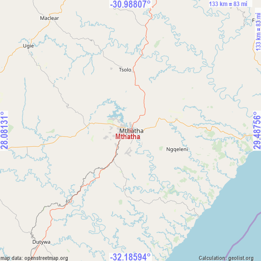
Mthatha GPS coordinates[2]
31° 35' 20.148" South, 28° 47' 3.948" East
| Map corner | latitude | longitude |
|---|---|---|
| Upper-left | -30.98807°, | 28.08131° |
| Center: | -31.58893°, | 28.78443° |
| Lower-right: | -32.18594°, | 29.48756° |
| Map W x H: | 133.2×133.2 km | = 82.8×82.8mi |
| max Lat: | -22.34881° ⇑77% North |
| Mthatha: | -31.58893° |
| min Lat: | ⇓23% South -34.66739° |
| min Long | Mthatha | max Long |
| 16.8697° | 28.78443° | 32.26762° |
| W 67.3%⇐ | ⇒32.7% E |
Elevation
Elevation of Mthatha is 694 m = 2277 ft, and this is 275.6 m = 904 ft below average elevation for this country.
| Max E: |
1873 m = 6145 ft | 69.6% |
| Avg. | 969.6 m = 3181 ft | |
| Mthatha | 694 m = 2277 ft | |
Min E: |
7 m = 23 ft | 30.4% |
See also: Mthatha elevation on elevation.city.
Geographical zone
Mthatha is located in South temperate zone (between Tropic of Capricorn and the Antarctic Circle). Distance of this Southern Tropic circle is 906.4 km =563.2 mi to North.| Distance of | km | miles | from Mthatha |
|---|---|---|---|
| Equator | 3512.4 | 2182.5 | to North |
| Tropic Capricorn | 906.4 | 563.2 | to North |
| Antarctic Circle | 3888.8 | 2416.4 | to South |
| South Pole | 6494.7 | 4035.6 | to South |


Nearby cities:
15 places around Mthatha: (largest is in red/bold)
• Barkly East
132.4 km =82.3 mi,  301°
301°
• Bizana
130.1 km =80.8 mi,  51°
51°
• Butterworth
101.9 km =63.3 mi,  215°
215°
• Cala
103.5 km =64.3 mi,  274°
274°
• Cofimvaba
122.7 km =76.2 mi,  248°
248°
• Elliot
93.1 km =57.8 mi,  287°
287°
• Flagstaff
88.1 km =54.7 mi, 50°
• Kokstad
130.9 km =81.3 mi,  27°
27°
• Komga
138.3 km =85.9 mi, 217°
• Libode
22.6 km =14 mi,  77°
77°
• Maclear
70.7 km =43.9 mi,  324°
324°
• Mount Ayliff
103 km =64 mi, 32°
• Mount Frere
78.9 km =49 mi,  14°
14°
• Port Saint John’s
72.1 km =44.8 mi,  93°
93°
• Qumbu
48.1 km =29.9 mi, 9°
Sources, notices
• [Note1] Compared only with cities in South Africa existing in our database
• [Src1] Map data: © OpenStreetMap contributors (CC-BY-SA)
• [Src2] Other city data from geonames.org with taken over terms of usage.
• [Src3] Geographical zone / Annual Mean Temperature by Robert A. Rohde @ Wikipedia
