Butterworth geodata
Butterworth (Eastern Cape) is a populated place; located in South Africa in Africa/Johannesburg (GMT+2) time zone. With population of 34,353 people, there are 115 cities with bigger population in this country. Compared to other cities in South Africa, 81.1% of cities are located further ↑North; 58.4% of cities are located further ←West and 73.5% of cities have higher elevation than Butterworth. Note1
Administrative division(s):
- Level 1: Eastern Cape
- Level 2: Amathole District Municipality
- Level 3: Mnquma


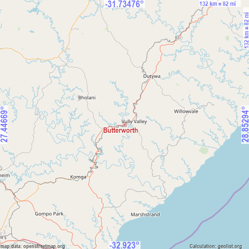
Butterworth GPS coordinates[2]
32° 19' 50.988" South, 28° 8' 59.316" East
| Map corner | latitude | longitude |
|---|---|---|
| Upper-left | -31.73476°, | 27.44669° |
| Center: | -32.33083°, | 28.14981° |
| Lower-right: | -32.923°, | 28.85294° |
| Map W x H: | 132.1×132.1 km | = 82.1×82.1mi |
| max Lat: | -22.34881° ⇑81.1% North |
| Butterworth: | -32.33083° |
| min Lat: | ⇓18.9% South -34.66739° |
| min Long | Butterworth | max Long |
| 16.8697° | 28.14981° | 32.26762° |
| W 58.4%⇐ | ⇒41.6% E |
Elevation
Elevation of Butterworth is 545 m = 1788 ft, and this is 424.6 m = 1393 ft below average elevation for this country.
| Max E: |
1873 m = 6145 ft | 73.5% |
| Avg. | 969.6 m = 3181 ft | |
| Butterworth | 545 m = 1788 ft | |
Min E: |
7 m = 23 ft | 26.5% |
See also: South Africa elevation on elevation.city.
Geographical zone
Butterworth is located in South temperate zone (between Tropic of Capricorn and the Antarctic Circle). Distance of this Southern Tropic circle is 988.9 km =614.5 mi to North.| Distance of | km | miles | from Butterworth |
|---|---|---|---|
| Equator | 3594.9 | 2233.8 | to North |
| Tropic Capricorn | 988.9 | 614.5 | to North |
| Antarctic Circle | 3806.3 | 2365.1 | to South |
| South Pole | 6412.2 | 3984.4 | to South |


Nearby cities:
15 places around Butterworth: (largest is in red/bold)
• Alice
133.3 km =82.8 mi,  247°
247°
• Bhisho
87.7 km =54.5 mi,  229°
229°
• Cala
99.5 km =61.8 mi,  334°
334°
• Cofimvaba
64.9 km =40.3 mi,  304°
304°
• East London
79.3 km =49.3 mi,  196°
196°
• Elliot
114.5 km =71.1 mi,  345°
345°
• Ilinge
111.4 km =69.2 mi,  290°
290°
• Komga
36.5 km =22.7 mi,  221°
221°
• Lady Frere
111.1 km =69 mi,  308°
308°
• Libode
119.8 km =74.4 mi,  43°
43°
• Mthatha
101.9 km =63.3 mi, 35°
• Queensdale
121.6 km =75.6 mi, 294°
• Queenstown
129.3 km =80.3 mi, 291°
• Stutterheim
73.1 km =45.4 mi, 248°
• Whittlesea
125.8 km =78.2 mi,  277°
277°
Sources, notices
• [Note1] Compared only with cities in South Africa existing in our database
• [Src1] Map data: © OpenStreetMap contributors (CC-BY-SA)
• [Src2] Other city data from geonames.org with taken over terms of usage.
• [Src3] Geographical zone / Annual Mean Temperature by Robert A. Rohde @ Wikipedia
