Lady Frere geodata
Lady Frere (Eastern Cape) is a seat of a third-order administrative division; located in South Africa in Africa/Johannesburg (GMT+2) time zone. With population of 25,041 people, there are 135 cities with bigger population in this country. Compared to other cities in South Africa, 77.9% of cities are located further ↑North; 55.8% of cities are located further →East and 55.5% of cities have higher elevation than Lady Frere. Note1
Administrative division(s):
- Level 1: Eastern Cape
- Level 2: Chris Hani District Municipality
- Level 3: Emalahleni


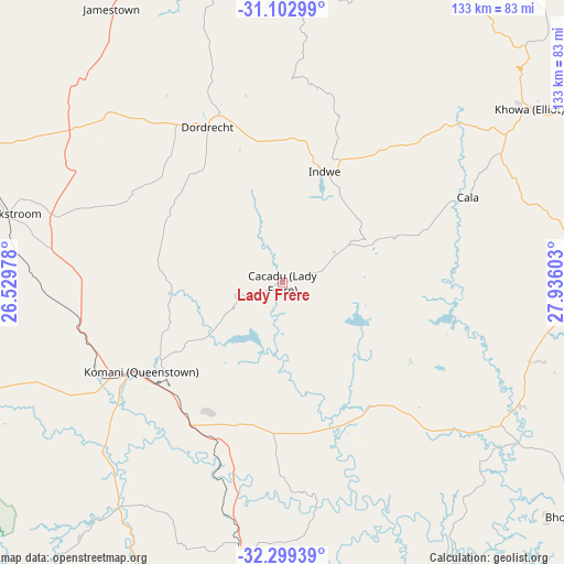
Lady Frere GPS coordinates[2]
31° 42' 11.232" South, 27° 13' 58.44" East
| Map corner | latitude | longitude |
|---|---|---|
| Upper-left | -31.10299°, | 26.52978° |
| Center: | -31.70312°, | 27.2329° |
| Lower-right: | -32.29939°, | 27.93603° |
| Map W x H: | 133×133 km | = 82.6×82.6mi |
| max Lat: | -22.34881° ⇑77.9% North |
| Lady Frere: | -31.70312° |
| min Lat: | ⇓22.1% South -34.66739° |
| min Long | Lady Frere | max Long |
| 16.8697° | 27.2329° | 32.26762° |
| W 44.2%⇐ | ⇒55.8% E |
Elevation
Elevation of Lady Frere is 1020 m = 3346 ft, and this is 50.4 m = 165 ft above average elevation for this country.
| Max E: |
1873 m = 6145 ft | 55.5% |
| Lady Frere | 1020 m 3346 ft | |
| Avg. | 969.6 m = 3181 ft | |
Min E: |
7 m = 23 ft | 44.5% |
See also: South Africa elevation on elevation.city.
Geographical zone
Lady Frere is located in South temperate zone (between Tropic of Capricorn and the Antarctic Circle). Distance of this Southern Tropic circle is 919.1 km =571.1 mi to North.| Distance of | km | miles | from Lady Frere |
|---|---|---|---|
| Equator | 3525.1 | 2190.4 | to North |
| Tropic Capricorn | 919.1 | 571.1 | to North |
| Antarctic Circle | 3876.1 | 2408.5 | to South |
| South Pole | 6482 | 4027.7 | to South |


Nearby cities:
15 places around Lady Frere: (largest is in red/bold)
• Barkly East
88.7 km =55.1 mi,  22°
22°
• Butterworth
111.1 km =69 mi,  128°
128°
• Cala
48.1 km =29.9 mi,  65°
65°
• Cofimvaba
46.6 km =29 mi,  135°
135°
• Dordrecht
40.7 km =25.3 mi,  334°
334°
• Elliot
71.5 km =44.4 mi,  54°
54°
• Ilinge
35.3 km =21.9 mi,  210°
210°
• Komga
115.3 km =71.6 mi,  147°
147°
• Lady Grey
110.3 km =68.5 mi,  359°
359°
• Molteno
89.2 km =55.4 mi,  292°
292°
• Queensdale
30.4 km =18.9 mi,  232°
232°
• Queenstown
40.1 km =24.9 mi,  237°
237°
• Stutterheim
98.1 km =61 mi,  169°
169°
• Tarkastad
98 km =60.9 mi,  249°
249°
• Whittlesea
65.2 km =40.5 mi,  216°
216°
Sources, notices
• [Note1] Compared only with cities in South Africa existing in our database
• [Src1] Map data: © OpenStreetMap contributors (CC-BY-SA)
• [Src2] Other city data from geonames.org with taken over terms of usage.
• [Src3] Geographical zone / Annual Mean Temperature by Robert A. Rohde @ Wikipedia
