Queenstown geodata
Queenstown (Eastern Cape) is a seat of a second-order administrative division; located in South Africa in Africa/Johannesburg (GMT+2) time zone. With population of 105,309 people, there are 50 cities with bigger population in this country. Compared to other cities in South Africa, 78.5% of cities are located further ↑North; 60.2% of cities are located further →East and 52.2% of cities have higher elevation than Queenstown. Note1
Administrative division(s):
- Level 1: Eastern Cape
- Level 2: Chris Hani District Municipality
- Level 3: Lukanji


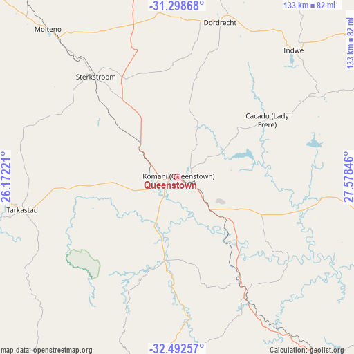
Queenstown GPS coordinates[2]
31° 53' 51.216" South, 26° 52' 31.188" East
| Map corner | latitude | longitude |
|---|---|---|
| Upper-left | -31.29868°, | 26.17221° |
| Center: | -31.89756°, | 26.87533° |
| Lower-right: | -32.49257°, | 27.57846° |
| Map W x H: | 132.7×132.7 km | = 82.5×82.5mi |
| max Lat: | -22.34881° ⇑78.5% North |
| Queenstown: | -31.89756° |
| min Lat: | ⇓21.5% South -34.66739° |
| min Long | Queenstown | max Long |
| 16.8697° | 26.87533° | 32.26762° |
| W 39.8%⇐ | ⇒60.2% E |
Elevation
Elevation of Queenstown is 1081 m = 3547 ft, and this is 111.4 m = 365 ft above average elevation for this country.
| Max E: |
1873 m = 6145 ft | 52.2% |
| Queenstown | 1081 m 3547 ft | |
| Avg. | 969.6 m = 3181 ft | |
Min E: |
7 m = 23 ft | 47.8% |
See also: Queenstown elevation on elevation.city.
Geographical zone
Queenstown is located in South temperate zone (between Tropic of Capricorn and the Antarctic Circle). Distance of this Southern Tropic circle is 940.8 km =584.6 mi to North.| Distance of | km | miles | from Queenstown |
|---|---|---|---|
| Equator | 3546.7 | 2203.8 | to North |
| Tropic Capricorn | 940.8 | 584.6 | to North |
| Antarctic Circle | 3854.5 | 2395.1 | to South |
| South Pole | 6460.4 | 4014.3 | to South |


Nearby cities:
15 places around Queenstown: (largest is in red/bold)
• Adelaide
105.3 km =65.4 mi,  211°
211°
• Alice
99 km =61.5 mi,  182°
182°
• Burgersdorp
112.7 km =70 mi,  332°
332°
• Cala
88 km =54.7 mi,  61°
61°
• Cofimvaba
67.5 km =41.9 mi,  99°
99°
• Dordrecht
60.7 km =37.7 mi,  15°
15°
• Elliot
111.6 km =69.3 mi, 55°
• Fort Beaufort
100.1 km =62.2 mi,  193°
193°
• Ilinge
18.1 km =11.2 mi,  119°
119°
• Lady Frere
40.1 km =24.9 mi, 57°
• Molteno
73.9 km =45.9 mi,  318°
318°
• Queensdale
10.2 km =6.3 mi,  73°
73°
• Stutterheim
90.9 km =56.5 mi,  145°
145°
• Tarkastad
59.4 km =36.9 mi,  257°
257°
• Whittlesea
31.3 km =19.4 mi, 188°
Sources, notices
• [Note1] Compared only with cities in South Africa existing in our database
• [Src1] Map data: © OpenStreetMap contributors (CC-BY-SA)
• [Src2] Other city data from geonames.org with taken over terms of usage.
• [Src3] Geographical zone / Annual Mean Temperature by Robert A. Rohde @ Wikipedia
