Cofimvaba geodata
Cofimvaba (Eastern Cape) is a seat of a third-order administrative division; located in South Africa in Africa/Johannesburg (GMT+2) time zone. In our database, there are 257 cities with bigger population. Compared to other cities in South Africa, 79.4% of cities are located further ↑North; 51.3% of cities are located further →East and 59% of cities have higher elevation than Cofimvaba. Note1
Administrative division(s):
- Level 1: Eastern Cape
- Level 2: Chris Hani District Municipality
- Level 3: Intsika Yethu


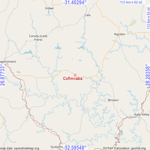
Cofimvaba GPS coordinates[2]
32° 0' 4.14" South, 27° 34' 49.62" East
| Map corner | latitude | longitude |
|---|---|---|
| Upper-left | -31.40294°, | 26.87733° |
| Center: | -32.00115°, | 27.58045° |
| Lower-right: | -32.59548°, | 28.28358° |
| Map W x H: | 132.6×132.6 km | = 82.4×82.4mi |
| max Lat: | -22.34881° ⇑79.4% North |
| Cofimvaba: | -32.00115° |
| min Lat: | ⇓20.6% South -34.66739° |
| min Long | Cofimvaba | max Long |
| 16.8697° | 27.58045° | 32.26762° |
| W 48.7%⇐ | ⇒51.3% E |
Elevation
Elevation of Cofimvaba is 959 m = 3146 ft, and this is 10.6 m = 35 ft below average elevation for this country.
| Max E: |
1873 m = 6145 ft | 59% |
| Avg. | 969.6 m = 3181 ft | |
| Cofimvaba | 959 m = 3146 ft | |
Min E: |
7 m = 23 ft | 41% |
See also: South Africa elevation on elevation.city.
Geographical zone
Cofimvaba is located in South temperate zone (between Tropic of Capricorn and the Antarctic Circle). Distance of this Southern Tropic circle is 952.3 km =591.7 mi to North.| Distance of | km | miles | from Cofimvaba |
|---|---|---|---|
| Equator | 3558.2 | 2211 | to North |
| Tropic Capricorn | 952.3 | 591.7 | to North |
| Antarctic Circle | 3843 | 2387.9 | to South |
| South Pole | 6448.9 | 4007.2 | to South |


Nearby cities:
15 places around Cofimvaba: (largest is in red/bold)
• Alice
112 km =69.6 mi,  218°
218°
• Barkly East
114.9 km =71.4 mi,  0°
0°
• Bhisho
95 km =59 mi,  187°
187°
• Butterworth
64.9 km =40.3 mi,  124°
124°
• Cala
54.2 km =33.7 mi,  11°
11°
• Dordrecht
86.2 km =53.6 mi,  324°
324°
• East London
117 km =72.7 mi,  164°
164°
• Elliot
78.5 km =48.8 mi,  18°
18°
• Ilinge
50.8 km =31.6 mi,  273°
273°
• Komga
70.4 km =43.7 mi, 155°
• Lady Frere
46.6 km =29 mi, 315°
• Queensdale
58.6 km =36.4 mi,  284°
284°
• Queenstown
67.5 km =41.9 mi, 279°
• Stutterheim
65 km =40.4 mi, 193°
• Whittlesea
73.8 km =45.9 mi,  254°
254°
Sources, notices
• [Note1] Compared only with cities in South Africa existing in our database
• [Src1] Map data: © OpenStreetMap contributors (CC-BY-SA)
• [Src2] Other city data from geonames.org with taken over terms of usage.
• [Src3] Geographical zone / Annual Mean Temperature by Robert A. Rohde @ Wikipedia
