Ladismith geodata
Ladismith (Western Cape) is a seat of a third-order administrative division; located in South Africa in Africa/Johannesburg (GMT+2) time zone. With population of 7,127 people, there are 227 cities with bigger population in this country. Compared to other cities in South Africa, 88.2% of cities are located further ↑North; 86.4% of cities are located further →East and 73.7% of cities have higher elevation than Ladismith. Note1
Administrative division(s):
- Level 1: Western Cape
- Level 2: Eden District Municipality
- Level 3: Kannaland


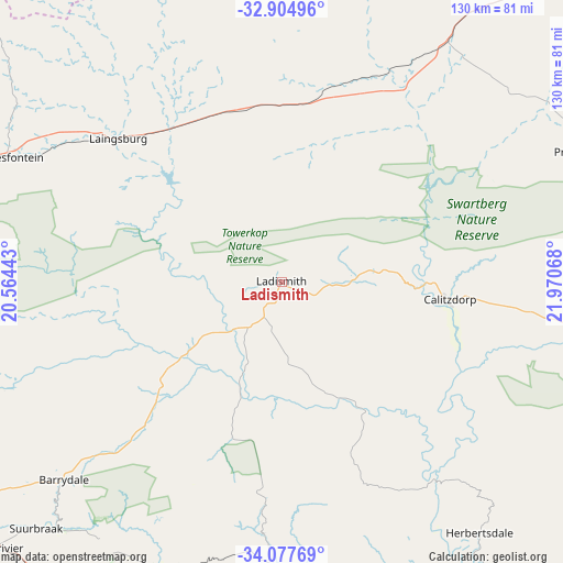
Ladismith GPS coordinates[2]
33° 29' 35.916" South, 21° 16' 3.18" East
| Map corner | latitude | longitude |
|---|---|---|
| Upper-left | -32.90496°, | 20.56443° |
| Center: | -33.49331°, | 21.26755° |
| Lower-right: | -34.07769°, | 21.97068° |
| Map W x H: | 130.4×130.4 km | = 81×81mi |
| max Lat: | -22.34881° ⇑88.2% North |
| Ladismith: | -33.49331° |
| min Lat: | ⇓11.8% South -34.66739° |
| min Long | Ladismith | max Long |
| 16.8697° | 21.26755° | 32.26762° |
| W 13.6%⇐ | ⇒86.4% E |
Elevation
Elevation of Ladismith is 544 m = 1785 ft, and this is 425.6 m = 1396 ft below average elevation for this country.
| Max E: |
1873 m = 6145 ft | 73.7% |
| Avg. | 969.6 m = 3181 ft | |
| Ladismith | 544 m = 1785 ft | |
Min E: |
7 m = 23 ft | 26.3% |
See also: South Africa elevation on elevation.city.
Geographical zone
Ladismith is located in South temperate zone (between Tropic of Capricorn and the Antarctic Circle). Distance of this Southern Tropic circle is 1118.2 km =694.8 mi to North.| Distance of | km | miles | from Ladismith |
|---|---|---|---|
| Equator | 3724.1 | 2314 | to North |
| Tropic Capricorn | 1118.2 | 694.8 | to North |
| Antarctic Circle | 3677.1 | 2284.8 | to South |
| South Pole | 6283 | 3904.1 | to South |


Nearby cities:
15 places around Ladismith: (largest is in red/bold)
• Albertina
84.3 km =52.4 mi,  159°
159°
• Ashton
118.3 km =73.5 mi,  251°
251°
• Calitzdorp
38.1 km =23.7 mi,  95°
95°
• De Rust
117.5 km =73 mi,  89°
89°
• George
122.2 km =75.9 mi,  115°
115°
• Hardys Memories of Africa
68.5 km =42.6 mi,  228°
228°
• Laingsburg
50.4 km =31.3 mi,  311°
311°
• Montagu
111 km =69 mi, 252°
• Mossel Bay
111.6 km =69.3 mi,  133°
133°
• Oudtshoorn
87.2 km =54.2 mi, 97°
• Prince Albert
76.6 km =47.6 mi,  67°
67°
• Riversdale
66.7 km =41.4 mi,  180°
180°
• Robertson
132.5 km =82.3 mi, 254°
• Swellendam
96.4 km =59.9 mi, 232°
• Zoar
16.3 km =10.1 mi, 90°
Sources, notices
• [Note1] Compared only with cities in South Africa existing in our database
• [Src1] Map data: © OpenStreetMap contributors (CC-BY-SA)
• [Src2] Other city data from geonames.org with taken over terms of usage.
• [Src3] Geographical zone / Annual Mean Temperature by Robert A. Rohde @ Wikipedia
