Albertina geodata
Albertina (Western Cape) is a populated place; located in South Africa in Africa/Johannesburg (GMT+2) time zone. With population of 6,372 people, there are 231 cities with bigger population in this country. Compared to other cities in South Africa, 98.8% of cities are located further ↑North; 85.5% of cities are located further →East and 83.8% of cities have higher elevation than Albertina. Note1
Administrative division(s):
- Level 1: Western Cape
- Level 2: Eden District Municipality
- Level 3: Hessequa


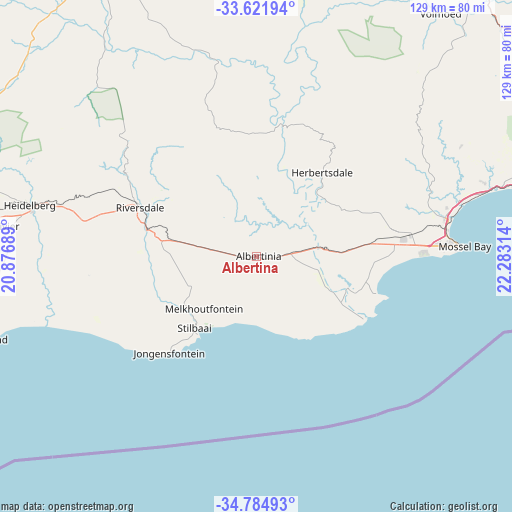
Albertina GPS coordinates[2]
34° 12' 19.584" South, 21° 34' 48.036" East
| Map corner | latitude | longitude |
|---|---|---|
| Upper-left | -33.62194°, | 20.87689° |
| Center: | -34.20544°, | 21.58001° |
| Lower-right: | -34.78493°, | 22.28314° |
| Map W x H: | 129.3×129.3 km | = 80.3×80.3mi |
| max Lat: | -22.34881° ⇑98.8% North |
| Albertina: | -34.20544° |
| min Lat: | ⇓1.2% South -34.66739° |
| min Long | Albertina | max Long |
| 16.8697° | 21.58001° | 32.26762° |
| W 14.5%⇐ | ⇒85.5% E |
Elevation
Elevation of Albertina is 183 m = 600 ft, and this is 786.6 m = 2581 ft below average elevation for this country.
| Max E: |
1873 m = 6145 ft | 83.8% |
| Avg. | 969.6 m = 3181 ft | |
| Albertina | 183 m = 600 ft | |
Min E: |
7 m = 23 ft | 16.2% |
See also: South Africa elevation on elevation.city.
Geographical zone
Albertina is located in South temperate zone (between Tropic of Capricorn and the Antarctic Circle). Distance of this Southern Tropic circle is 1197.4 km =744 mi to North.| Distance of | km | miles | from Albertina |
|---|---|---|---|
| Equator | 3803.3 | 2363.3 | to North |
| Tropic Capricorn | 1197.4 | 744 | to North |
| Antarctic Circle | 3597.9 | 2235.6 | to South |
| South Pole | 6203.8 | 3854.9 | to South |


Nearby cities:
15 places around Albertina: (largest is in red/bold)
• Arniston
134 km =83.3 mi,  247°
247°
• Calitzdorp
75.9 km =47.2 mi,  6°
6°
• De Rust
118.8 km =73.8 mi,  47°
47°
• George
85.6 km =53.2 mi,  71°
71°
• Hardys Memories of Africa
86.2 km =53.6 mi,  292°
292°
• Knysna
136.3 km =84.7 mi,  82°
82°
• Ladismith
84.3 km =52.4 mi,  339°
339°
• Laingsburg
130.7 km =81.2 mi,  329°
329°
• Montagu
142.3 km =88.4 mi, 289°
• Mossel Bay
52.1 km =32.4 mi,  87°
87°
• Oudtshoorn
88.3 km =54.9 mi,  40°
40°
• Prince Albert
116.6 km =72.5 mi,  20°
20°
• Riversdale
32.2 km =20 mi, 292°
• Swellendam
106.7 km =66.3 mi,  280°
280°
• Zoar
79.9 km =49.6 mi,  350°
350°
Sources, notices
• [Note1] Compared only with cities in South Africa existing in our database
• [Src1] Map data: © OpenStreetMap contributors (CC-BY-SA)
• [Src2] Other city data from geonames.org with taken over terms of usage.
• [Src3] Geographical zone / Annual Mean Temperature by Robert A. Rohde @ Wikipedia
