Prince Albert geodata
Prince Albert (Western Cape) is a seat of a third-order administrative division; located in South Africa in Africa/Johannesburg (GMT+2) time zone. With population of 13,136 people, there are 180 cities with bigger population in this country. Compared to other cities in South Africa, 86.1% of cities are located further ↑North; 84.4% of cities are located further →East and 71.1% of cities have higher elevation than Prince Albert. Note1
Administrative division(s):
- Level 1: Western Cape
- Level 2: Central Karoo District Municipality
- Level 3: Prince Albert


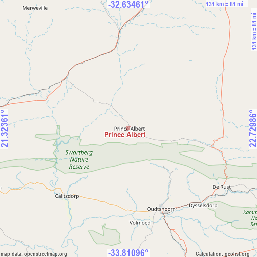
Prince Albert GPS coordinates[2]
33° 13' 29.136" South, 22° 1' 36.228" East
| Map corner | latitude | longitude |
|---|---|---|
| Upper-left | -32.63461°, | 21.32361° |
| Center: | -33.22476°, | 22.02673° |
| Lower-right: | -33.81096°, | 22.72986° |
| Map W x H: | 130.8×130.8 km | = 81.3×81.3mi |
| max Lat: | -22.34881° ⇑86.1% North |
| Prince Albert: | -33.22476° |
| min Lat: | ⇓13.9% South -34.66739° |
| min Long | Prince Albert | max Long |
| 16.8697° | 22.02673° | 32.26762° |
| W 15.6%⇐ | ⇒84.4% E |
Elevation
Elevation of Prince Albert is 633 m = 2077 ft, and this is 336.6 m = 1104 ft below average elevation for this country.
| Max E: |
1873 m = 6145 ft | 71.1% |
| Avg. | 969.6 m = 3181 ft | |
| Prince Albert | 633 m = 2077 ft | |
Min E: |
7 m = 23 ft | 28.9% |
See also: South Africa elevation on elevation.city.
Geographical zone
Prince Albert is located in South temperate zone (between Tropic of Capricorn and the Antarctic Circle). Distance of this Southern Tropic circle is 1088.3 km =676.2 mi to North.| Distance of | km | miles | from Prince Albert |
|---|---|---|---|
| Equator | 3694.2 | 2295.5 | to North |
| Tropic Capricorn | 1088.3 | 676.2 | to North |
| Antarctic Circle | 3706.9 | 2303.4 | to South |
| South Pole | 6312.8 | 3922.6 | to South |


Nearby cities:
15 places around Prince Albert: (largest is in red/bold)
• Albertina
116.6 km =72.5 mi,  200°
200°
• Beaufort West
109.6 km =68.1 mi,  28°
28°
• Calitzdorp
46.8 km =29.1 mi,  224°
224°
• De Rust
55.7 km =34.6 mi,  122°
122°
• Fraserburg
153.3 km =95.3 mi,  341°
341°
• George
91.4 km =56.8 mi,  153°
153°
• Hardys Memories of Africa
143 km =88.9 mi,  238°
238°
• Knysna
130.6 km =81.2 mi,  133°
133°
• Ladismith
76.6 km =47.6 mi,  247°
247°
• Laingsburg
108.7 km =67.5 mi,  271°
271°
• Mossel Bay
107.1 km =66.5 mi,  174°
174°
• Oudtshoorn
44.7 km =27.8 mi,  158°
158°
• Riversdale
120 km =74.6 mi, 216°
• Willowmore
136.2 km =84.6 mi,  93°
93°
• Zoar
62 km =38.5 mi, 240°
Sources, notices
• [Note1] Compared only with cities in South Africa existing in our database
• [Src1] Map data: © OpenStreetMap contributors (CC-BY-SA)
• [Src2] Other city data from geonames.org with taken over terms of usage.
• [Src3] Geographical zone / Annual Mean Temperature by Robert A. Rohde @ Wikipedia
