Laingsburg geodata
Laingsburg (Western Cape) is a seat of a third-order administrative division; located in South Africa in Africa/Johannesburg (GMT+2) time zone. In our database, there are 257 cities with bigger population. Compared to other cities in South Africa, 85.5% of cities are located further ↑North; 87.9% of cities are located further →East and 70.5% of cities have higher elevation than Laingsburg. Note1
Administrative division(s):
- Level 1: Western Cape
- Level 2: Central Karoo District Municipality
- Level 3: Laingsburg


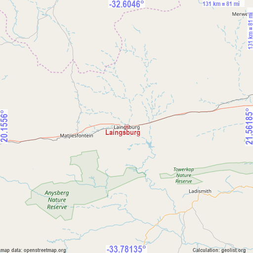
Laingsburg GPS coordinates[2]
33° 11' 41.82" South, 20° 51' 31.392" East
| Map corner | latitude | longitude |
|---|---|---|
| Upper-left | -32.6046°, | 20.1556° |
| Center: | -33.19495°, | 20.85872° |
| Lower-right: | -33.78135°, | 21.56185° |
| Map W x H: | 130.8×130.8 km | = 81.3×81.3mi |
| max Lat: | -22.34881° ⇑85.5% North |
| Laingsburg: | -33.19495° |
| min Lat: | ⇓14.5% South -34.66739° |
| min Long | Laingsburg | max Long |
| 16.8697° | 20.85872° | 32.26762° |
| W 12.1%⇐ | ⇒87.9% E |
Elevation
Elevation of Laingsburg is 654 m = 2146 ft, and this is 315.6 m = 1035 ft below average elevation for this country.
| Max E: |
1873 m = 6145 ft | 70.5% |
| Avg. | 969.6 m = 3181 ft | |
| Laingsburg | 654 m = 2146 ft | |
Min E: |
7 m = 23 ft | 29.5% |
See also: South Africa elevation on elevation.city.
Geographical zone
Laingsburg is located in South temperate zone (between Tropic of Capricorn and the Antarctic Circle). Distance of this Southern Tropic circle is 1085 km =674.2 mi to North.| Distance of | km | miles | from Laingsburg |
|---|---|---|---|
| Equator | 3690.9 | 2293.4 | to North |
| Tropic Capricorn | 1085 | 674.2 | to North |
| Antarctic Circle | 3710.2 | 2305.4 | to South |
| South Pole | 6316.1 | 3924.6 | to South |


Nearby cities:
15 places around Laingsburg: (largest is in red/bold)
• Albertina
130.7 km =81.2 mi,  149°
149°
• Ashton
102.7 km =63.8 mi,  226°
226°
• Calitzdorp
84.4 km =52.4 mi,  115°
115°
• Ceres
145.2 km =90.2 mi,  262°
262°
• Fraserburg
154.9 km =96.3 mi,  23°
23°
• Hardys Memories of Africa
80.1 km =49.8 mi,  189°
189°
• Ladismith
50.4 km =31.3 mi,  131°
131°
• Montagu
94.9 km =59 mi, 226°
• Oudtshoorn
132.4 km =82.3 mi,  109°
109°
• Prince Albert
108.7 km =67.5 mi,  91°
91°
• Riversdale
106.5 km =66.2 mi,  159°
159°
• Robertson
112.8 km =70.1 mi, 233°
• Swellendam
99.8 km =62 mi,  202°
202°
• Worcester
140.2 km =87.1 mi,  249°
249°
• Zoar
63.8 km =39.6 mi, 121°
Sources, notices
• [Note1] Compared only with cities in South Africa existing in our database
• [Src1] Map data: © OpenStreetMap contributors (CC-BY-SA)
• [Src2] Other city data from geonames.org with taken over terms of usage.
• [Src3] Geographical zone / Annual Mean Temperature by Robert A. Rohde @ Wikipedia
