De Rust geodata
De Rust (Western Cape) is a populated place; located in South Africa in Africa/Johannesburg (GMT+2) time zone. With population of 3,566 people, there are 243 cities with bigger population in this country. Compared to other cities in South Africa, 87.9% of cities are located further ↑North; 82.9% of cities are located further →East and 77% of cities have higher elevation than De Rust. Note1
Administrative division(s):
- Level 1: Western Cape
- Level 2: Eden District Municipality
- Level 3: Oudtshoorn


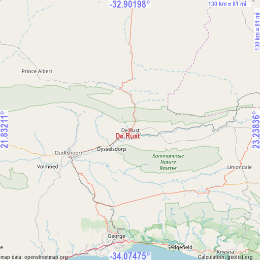
De Rust GPS coordinates[2]
33° 29' 25.26" South, 22° 32' 6.828" East
| Map corner | latitude | longitude |
|---|---|---|
| Upper-left | -32.90198°, | 21.83211° |
| Center: | -33.49035°, | 22.53523° |
| Lower-right: | -34.07475°, | 23.23836° |
| Map W x H: | 130.4×130.4 km | = 81×81mi |
| max Lat: | -22.34881° ⇑87.9% North |
| De Rust: | -33.49035° |
| min Lat: | ⇓12.1% South -34.66739° |
| min Long | De Rust | max Long |
| 16.8697° | 22.53523° | 32.26762° |
| W 17.1%⇐ | ⇒82.9% E |
Elevation
Elevation of De Rust is 475 m = 1558 ft, and this is 494.6 m = 1623 ft below average elevation for this country.
| Max E: |
1873 m = 6145 ft | 77% |
| Avg. | 969.6 m = 3181 ft | |
| De Rust | 475 m = 1558 ft | |
Min E: |
7 m = 23 ft | 23% |
See also: South Africa elevation on elevation.city.
Geographical zone
De Rust is located in South temperate zone (between Tropic of Capricorn and the Antarctic Circle). Distance of this Southern Tropic circle is 1117.9 km =694.6 mi to North.| Distance of | km | miles | from De Rust |
|---|---|---|---|
| Equator | 3723.8 | 2313.9 | to North |
| Tropic Capricorn | 1117.9 | 694.6 | to North |
| Antarctic Circle | 3677.4 | 2285 | to South |
| South Pole | 6283.3 | 3904.3 | to South |


Nearby cities:
15 places around De Rust: (largest is in red/bold)
• Albertina
118.8 km =73.8 mi,  227°
227°
• Beaufort West
126.1 km =78.4 mi,  2°
2°
• Calitzdorp
79.7 km =49.5 mi,  267°
267°
• George
53 km =32.9 mi,  187°
187°
• Kareedouw
170.3 km =105.8 mi,  107°
107°
• Knysna
77 km =47.8 mi,  142°
142°
• Ladismith
117.5 km =73 mi, 269°
• Laingsburg
159.2 km =98.9 mi,  281°
281°
• Mossel Bay
85 km =52.8 mi,  205°
205°
• Oudtshoorn
33.4 km =20.8 mi,  248°
248°
• Plettenberg Bay
99.4 km =61.8 mi,  128°
128°
• Prince Albert
55.7 km =34.6 mi,  302°
302°
• Riversdale
135.8 km =84.4 mi,  240°
240°
• Willowmore
91.3 km =56.7 mi,  76°
76°
• Zoar
101.2 km =62.9 mi, 269°
Sources, notices
• [Note1] Compared only with cities in South Africa existing in our database
• [Src1] Map data: © OpenStreetMap contributors (CC-BY-SA)
• [Src2] Other city data from geonames.org with taken over terms of usage.
• [Src3] Geographical zone / Annual Mean Temperature by Robert A. Rohde @ Wikipedia
